Geolocate
👉 Easily get elevation data in JSON, GeoTIFF and KML formats using Elevation API
Thank you for supporting this site ❤️
Make a donation

Reforma topographic map

Click on the map to display elevation.

👉 Easily get elevation data in JSON, GeoTIFF and KML formats using Elevation API
Thank you for supporting this site ❤️
Make a donation

About this map

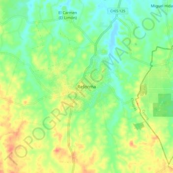
Name: Reforma topographic map, elevation, terrain.

Location: Reforma, Chiapas, 29500, Mexico (17.81810 -93.19557 17.89810 -93.11557)

Average elevation: 27 m

Minimum elevation: 7 m

Maximum elevation: 54 m