
Liebenau topographic map
Interactive map
Click on the map to display elevation.
About this map
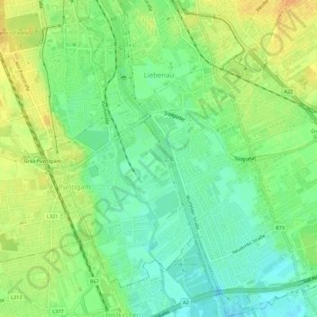
Name: Liebenau topographic map, elevation, terrain.
Location: Liebenau, Graz, Steiermark, 8041, Österreich (47.01189 15.44245 47.04888 15.48864)
Average elevation: 343 m
Minimum elevation: 328 m
Maximum elevation: 359 m
Other topographic maps
Click on a map to view its topography, its elevation and its terrain.
Puntigam
Österreich > Steiermark > Graz
Puntigam, Graz, Steiermark, Österreich
Average elevation: 345 m
Weizberg
Österreich > Steiermark > Graz
Weizberg, Andritz, Graz, Steiermark, 8043, Österreich
Average elevation: 485 m