
Thank you for supporting this site ❤️
Make a donation
Make a donation
Sector 13 topographic map
Click on the map to display elevation.
Thank you for supporting this site ❤️
Make a donation
Make a donation
About this map
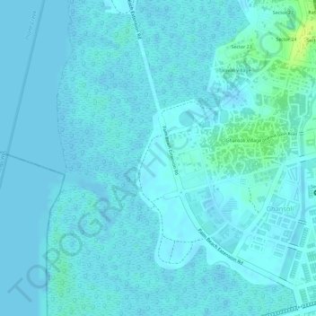
Name: Sector 13 topographic map, elevation, terrain.
Location: Sector 13, Ghansoli, Navi Mumbai, Thane, Maharashtra, India (19.11970 72.98661 19.12758 72.99059)
Average elevation: 3 m
Minimum elevation: -3 m
Maximum elevation: 18 m
Thank you for supporting this site ❤️
Make a donation
Make a donation
Other topographic maps
Click on a map to view its topography, its elevation and its terrain.
Navi Mumbai
India > Maharashtra > Thane > Navi Mumbai
Navi Mumbai (Marathi pronunciation: , also known by its former name New Bombay), is a planned city off the west coast of the Indian state of Maharashtra in Konkan division. The city is divided into two parts, North Navi Mumbai and South Navi Mumbai, for the individual development of Panvel Mega City, which…
Average elevation: 30 m