
Hilden topographic map
Interactive map
Click on the map to display elevation.
About this map
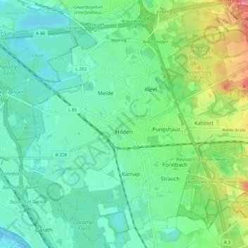
Name: Hilden topographic map, elevation, terrain.
Location: Hilden, Kreis Mettmann, Noordrijn-Westfalen, Duitsland (51.14050 6.89076 51.19797 6.98635)
Average elevation: 55 m
Minimum elevation: 34 m
Maximum elevation: 109 m
Other topographic maps
Click on a map to view its topography, its elevation and its terrain.
Rijn
Duitsland > Noordrijn-Westfalen > Kreis Mettmann
Rijn, Kreis Mettmann, Noordrijn-Westfalen, Duitsland
Average elevation: 77 m
Langenfeld (Rheinland)
Duitsland > Noordrijn-Westfalen > Kreis Mettmann
Langenfeld (Rheinland), Kreis Mettmann, Noordrijn-Westfalen, 40764, Duitsland
Average elevation: 55 m