
Langenfeld (Rheinland) topographic map
Interactive map
Click on the map to display elevation.
About this map
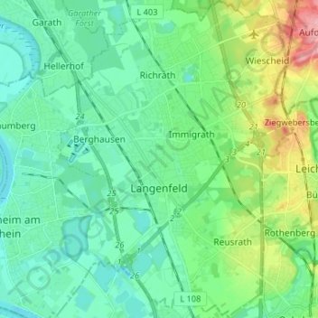
Name: Langenfeld (Rheinland) topographic map, elevation, terrain.
Average elevation: 55 m
Minimum elevation: 31 m
Maximum elevation: 128 m
Other topographic maps
Click on a map to view its topography, its elevation and its terrain.
Rijn
Duitsland > Noordrijn-Westfalen > Kreis Mettmann
Rijn, Kreis Mettmann, Noordrijn-Westfalen, Duitsland
Average elevation: 77 m
Hilden
Duitsland > Noordrijn-Westfalen > Kreis Mettmann
Hilden, Kreis Mettmann, Noordrijn-Westfalen, Duitsland
Average elevation: 55 m