
County Limerick topographic map
Interactive map
Click on the map to display elevation.
About this map
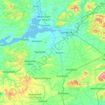
Name: County Limerick topographic map, elevation, terrain.
Location: County Limerick, Munster, Irland (52.28020 -9.36543 52.75738 -8.15639)
Average elevation: 110 m
Minimum elevation: -1 m
Maximum elevation: 811 m
Other topographic maps
Click on a map to view its topography, its elevation and its terrain.
Abbeyfeale
Irland > County Limerick > The Municipal District of Newcastle West
Abbeyfeale, The Municipal District of Newcastle West, County Limerick, Munster, Irland
Average elevation: 150 m
Abbeyfeale
Irland > County Limerick > The Municipal District of Newcastle West > Abbeyfeale
Abbeyfeale, The Municipal District of Newcastle West, County Limerick, Munster, Irland
Average elevation: 122 m