
Thank you for supporting this site ❤️
Make a donation
Make a donation
Meers topographic map
Click on the map to display elevation.
Thank you for supporting this site ❤️
Make a donation
Make a donation
About this map
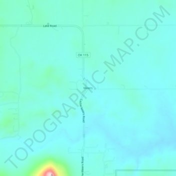
Name: Meers topographic map, elevation, terrain.
Location: Meers, Comanche County, Oklahoma, United States (34.76286 -98.59896 34.80286 -98.55896)
Average elevation: 457 m
Minimum elevation: 417 m
Maximum elevation: 734 m
Thank you for supporting this site ❤️
Make a donation
Make a donation
Other topographic maps
Click on a map to view its topography, its elevation and its terrain.
Thank you for supporting this site ❤️
Make a donation
Make a donation
Thank you for supporting this site ❤️
Make a donation
Make a donation
Thank you for supporting this site ❤️
Make a donation
Make a donation