
Aurangpur topographic map
Interactive map
Click on the map to display elevation.
About this map
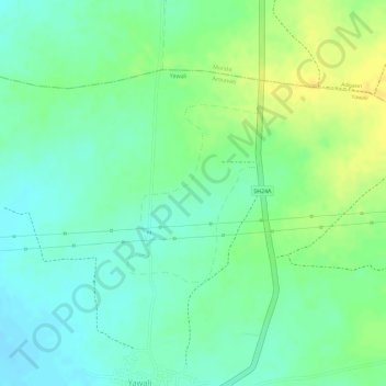
Name: Aurangpur topographic map, elevation, terrain.
Location: Aurangpur, Amravati, Maharashtra, India (21.11720 77.84581 21.12960 77.85592)
Average elevation: 352 m
Minimum elevation: 340 m
Maximum elevation: 365 m
Other topographic maps
Click on a map to view its topography, its elevation and its terrain.
Amravati
India > Maharashtra > Amravati
Amravati is located at 20°56′N 77°45′E / 20.93°N 77.75°E / 20.93; 77.75. It has an average elevation of 343 meters (1125 feet). It lies 156 km (97 mi) west of Nagpur and serves as the administrative centre of Amravati District and of Amravati Division. The city is located near the passes…
Average elevation: 345 m