
Enfidha topographic map
Interactive map
Click on the map to display elevation.
About this map
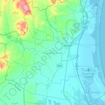
Name: Enfidha topographic map, elevation, terrain.
Location: Enfidha, Sousse, Tunisie (36.00104 10.18091 36.23429 10.47365)
Average elevation: 64 m
Minimum elevation: -4 m
Maximum elevation: 492 m
Other topographic maps
Click on a map to view its topography, its elevation and its terrain.
El Kalaa Essghira Est
El Kalaa Essghira Est, Kalaa Sghira, Sousse, 4021, Tunisie
Average elevation: 45 m