
Schinveld topographic map
Interactive map
Click on the map to display elevation.
About this map
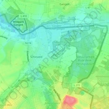
Name: Schinveld topographic map, elevation, terrain.
Location: Schinveld, Beekdaelen, Limburg, Netherlands (50.95754 5.95085 50.98382 6.02689)
Average elevation: 72 m
Minimum elevation: 48 m
Maximum elevation: 130 m
Other topographic maps
Click on a map to view its topography, its elevation and its terrain.
Cottessen
Netherlands > Limburg > Vijlen
Cottessen, Vijlen, Vaals, Limburg, Netherlands, 6294 NE, Netherlands
Average elevation: 183 m
Overheek
Netherlands > Limburg > Termaar
Overheek, Termaar, Klimmen, Voerendaal, Limburg, Netherlands, 6343 DB, Netherlands
Average elevation: 118 m
Hout-Blerick
Netherlands > Limburg > Venlo
Hout-Blerick, Venlo, Limburg, Netherlands, 5926 RA, Netherlands
Average elevation: 22 m
Valkenburg
Netherlands > Limburg > Valkenburg
Valkenburg, Valkenburg aan de Geul, Limburg, Netherlands
Average elevation: 123 m
Eijsden
Netherlands > Limburg > Eijsden
Eijsden, Eijsden-Margraten, Limburg, Netherlands
Average elevation: 73 m
Afferden
Netherlands > Limburg > Afferden
Afferden, Bergen, Limburg, Netherlands
Average elevation: 16 m
Maasbree
Netherlands > Limburg > Maasbree
Maasbree, Peel en Maas, Limburg, Netherlands
Average elevation: 29 m
Schimmert
Netherlands > Limburg > Schimmert > Schimmert
Schimmert, Beekdaelen, Limburg, Netherlands, 6333, Netherlands
Average elevation: 125 m
Brunssummerheide
Netherlands > Limburg > Heerlen
Brunssummerheide, Heerlen, Limburg, Netherlands, 6373CH, Netherlands
Average elevation: 105 m
Maastricht
Netherlands > Limburg > Maastricht
Maastricht, Limburg, Netherlands, 6211CL, Netherlands
Average elevation: 101 m
Horick
Netherlands > Limburg > Ospel > Horick
Horick, Ospel, Nederweert, Limburg, Netherlands, 6035, Netherlands
Average elevation: 32 m
Vijlen
Netherlands > Limburg > Vijlen
Vijlen, Limburg, Netherlands, 6294, Netherlands
Average elevation: 180 m
Valkenburg aan de Geul
Valkenburg aan de Geul, Limburg, Netherlands
Average elevation: 119 m
Herkenbosch
Netherlands > Limburg > Roerdalen
Herkenbosch, Roerdalen, Limburg, Netherlands
Average elevation: 49 m
Ubachsberg
Netherlands > Limburg > Ubachsberg
Ubachsberg, Limburg, Netherlands, 6367, Netherlands
Average elevation: 164 m
Houthem
Netherlands > Limburg > Houthem
Houthem, Limburg, Netherlands, 6301, Netherlands
Average elevation: 105 m
Nuth
Netherlands > Limburg > Nuth
Nuth, Limburg, Netherlands, 6361, Netherlands
Average elevation: 95 m
Horst aan de Maas
Horst aan de Maas, Limburg, Netherlands
Average elevation: 27 m
Klein-Kullen
Netherlands > Limburg > Epen > Klein-Kullen
Klein-Kullen, Epen, Gulpen-Wittem, Limburg, Netherlands, 6285NS, Netherlands
Average elevation: 185 m