
Horst aan de Maas topographic map
Interactive map
Click on the map to display elevation.
About this map
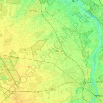
Name: Horst aan de Maas topographic map, elevation, terrain.
Location: Horst aan de Maas, Limburg, Netherlands, The Netherlands (51.37805 5.87497 51.52478 6.17898)
Average elevation: 27 m
Minimum elevation: 9 m
Maximum elevation: 50 m
Dutch Topographic map of the municipality of Horst aan de Maas, June 2015.