
Make a donation
Mount Bromo topographic map
Click on the map to display elevation.
Make a donation
About this map
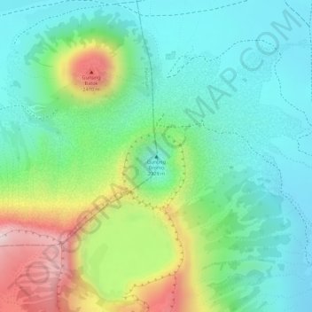
Name: Mount Bromo topographic map, elevation, terrain.
Location: Mount Bromo, Pasuruan, Indonesia (-7.94212 112.95293 -7.94202 112.95303)
Average elevation: 2,239 m
Minimum elevation: 2,110 m
Maximum elevation: 2,504 m
Make a donation
Other topographic maps
Click on a map to view its topography, its elevation and its terrain.
Semarang
Semarang is located on the northern coast of Java. The city of Semarang is one of the important cities located on the north coast of Java and as the main hub connecting Jakarta and Surabaya, and cities in the southern interior of Java Surakarta and Yogyakarta. Semarang City has a height ranging from 2 m (6.6…
Average elevation: 107 m
Pulau Bali
Bali features a diverse topography shaped by a volcanic origin, which significantly influences its landscapes and climate. The island is dominated by a central mountain range that runs from west to east, with Mount Agung, reaching an elevation of approximately 10,308 feet, standing as the highest peak and a…
Average elevation: 122 m
Make a donation
East Java
East Java has a tropical monsoon and savanna climate at lower elevation and subtropical at higher elevation. Compared with the western part of Java Island, East Java in general has less rainfall. Average rainfall is 1,900 mm per year, with a rainy season during the 100 days. The average temperature ranges…
Average elevation: 62 m
Make a donation
Borneo
Before sea levels rose at the end of the last Ice Age, Borneo was part of the mainland of Asia, forming, with Java and Sumatra, the upland regions of a peninsula that extended east from present day Indochina. The South China Sea and Gulf of Thailand now submerge the former low-lying areas of the peninsula.…
Average elevation: 141 m
Lombok
Indonesia > West Nusa Tenggara
The island's topography is dominated by the centrally-located stratovolcano Mount Rinjani, the second-highest volcano in Indonesia, which rises to 3,726 metres (12,224 ft), making Lombok the 8th-highest island. The most recent eruption of Rinjani occurred in September 2016 at Gunung Barujari. In a 2010…
Average elevation: 192 m
Borneo
Before sea levels rose at the end of the last ice age, Borneo was part of the mainland of Asia, forming, with Java and Sumatra, the upland regions of a peninsula that extended east from present day Indochina. The South China Sea and Gulf of Thailand now submerge the former low-lying areas of the peninsula.…
Average elevation: 141 m
Make a donation
Balikpapan
Topography of Balikpapan is generally hilly (85%), with only small areas of flat land (15%), mostly along the coast and surrounding the hilly areas. The hills are less than 100 meters (330 feet) higher than the adjacent valleys. The altitude of Balikpapan ranges from 0 to 80 meters (260 feet) above sea level.…
Average elevation: 21 m
Pecatu
Indonesia > Bali > Kuta Selatan
Pecatu is located in South Kuta District of Badung Regency. It is at the western end of the Bukit Peninsula in south Bali, and has a hilly topography with limestone cliffs isolating small, short beaches that have been privately developed. Nusa Dua, on the opposite side of the peninsula, is flat and is a…
Average elevation: 64 m
Make a donation
Special Capital Region of Jakarta
Jakarta lies in a low and flat alluvial plain, ranging from −2 to 91 m (−7 to 299 ft) with an average elevation of 8 m (26 ft) above sea level with historically extensive swampy areas. Some parts of the city have been constructed on reclaimed tidal flats that occur in around the area. Thirteen rivers flow…
Average elevation: 5 m
Jayapura
The topography of Jayapura varies from valleys to hills, plateaus, and mountains up to 700 metres (2,300 ft) above sea level. Jayapura overlooks the Yos Sudarso Bay. Jayapura is about 83,548 hectares (206,450 acres) in land area, and is divided into five districts. Around 30% of the area is inhabited, with the…
Average elevation: 161 m
Java
Java is an island with a large amount of biodiversity. The natural environment of Java is tropical rainforest, with ecosystems ranging from coastal mangrove forest on the north coast, rocky coastal cliffs on the southern coast, and low-lying tropical forest to high altitude rainforest on the slopes of…
Average elevation: 39 m
Make a donation
Java
Java is an island with a large amount of biodiversity. The natural environment of Java is tropical rainforest, with ecosystems ranging from coastal mangrove forest on the north coast, rocky coastal cliffs on the southern coast, and low-lying tropical forest to high altitude rainforest on the slopes of…
Average elevation: 39 m
Bandung City
Bandung (Sundanese: ᮘᮔ᮪ᮓᮥᮀ, romanized: Bandung, Sundanese pronunciation: [ˈbandʊŋ]; /ˈbɑːndʊŋ/) is the capital city of the Indonesian province of West Java. It has a population of 2,452,943 within its city limits according to the official estimates as at mid 2021, making it the fourth most…
Average elevation: 830 m
Make a donation
Bekasi
The City of Bekasi is a part of the Bekasi river basin, located in the downstream area of the basin with slopes ranging from 0 to 2% and elevations between 11 meters to 81 meters above sea level. The city of Bekasi is part of the Bekasi river basin and is located in the downstream area of the basin, with a…
Average elevation: 32 m
Lampung
Between 1969 and 1970, the total area of forest land in Lampung that had been used was 249,200 hectares. In 2000, there were 48 permits issued; in 1980, the number reached 76 permits. The topography of the region in the western part is mostly hilly, while the eastern part is mostly a lowland area that is…
Average elevation: 111 m
Make a donation
Sulawesi
The lowland forests on the island have mostly been removed. Because of the relative geological youth of the island and its dramatic and sharp topography, the lowland areas are naturally limited in their extent. The past decade has seen dramatic conversion of this rare and endangered habitat. The island also…
Average elevation: 98 m
Make a donation
Bali
Bali's central mountains include several peaks over 2,000 metres (6,600 feet) in elevation and active volcanoes such as Mount Batur. The highest is Mount Agung (3,031 m; 9,944 ft), known as the "mother mountain", which is an active volcano rated as one of the world's most likely sites for a massive eruption…
Average elevation: 88 m
Make a donation
Yahukimo
Yahukimo Regency is located in Highland Papua Province, Indonesia. Its geography consists mostly of mountainous areas and highlands. The regency has mountainous terrain and dense forests, with altitudes varying from lowlands to high mountains. This hilly topography makes access to some areas difficult and…
Average elevation: 1,320 m
Make a donation
Make a donation
Lhokseumawe
Lhokseumawe City is located between 4˚ - 5˚ North Latitude and 96˚ - 97˚ East Longitude with an average altitude of 13 metres above sea level. Lhokseumawe was given the status of an independent city (separate from North Aceh Regency, which surrounds it on all the landward sides) based on Law Number 2 of…
Average elevation: 10 m
Make a donation
Bali
Bali's central mountains include several peaks over 2,000 metres (6,600 feet) in elevation and active volcanoes such as Mount Batur. The highest is Mount Agung (3,031 m, 9,944 ft), known as the "mother mountain", which is an active volcano rated as one of the world's most likely sites for a massive eruption…
Average elevation: 88 m
Make a donation
Central Java
The Southern Serayu Mountains are part of the South Central Java Basin located in the southern part of the province. This mandala is a geoantiklin that extends from west to east along 100 kilometres and is divided into two parts separated by the Jatilawang valley, namely the western and eastern regions. The…
Average elevation: 83 m
Borneo
Before sea levels rose at the end of the last ice age, Borneo was part of the mainland of Asia, forming, with Java and Sumatra, the upland regions of a peninsula that extended east from present day Indochina. The South China Sea and Gulf of Thailand now submerge the former low-lying areas of the peninsula.…
Average elevation: 141 m
Make a donation
Pulau Bali
Bali's central mountains include several peaks over 2,000 metres (6,600 feet) in elevation and active volcanoes such as Mount Batur. The highest is Mount Agung (3,031 m, 9,944 ft), known as the "mother mountain", which is an active volcano rated as one of the world's most likely sites for a massive eruption…
Average elevation: 122 m
Temanggung
Temanggung Regency is located on the volcanic Dieng Plateau with an average elevation between 500 and 1450 meters. It is landlocked. The volcanoes Mount Sundoro and Mount Sumbing rise on its border with the Wonosobo Regency. Its major drainage system is the Progo River and its tributaries.
Average elevation: 771 m
Make a donation
North Sumatra
Half of the province is located on a high plateau that runs along the Bukit Barisan mountains, from central North Sumatra to the western coast. The tallest mountain in the province is Mount Sinabung in Karo Regency, at elevation around 2,460 metres (8,070 ft), the most active volcano in the region. Volcanic…
Average elevation: 200 m
Tangerang
Topographically, Tangerang City is mostly located at an altitude of 10-30 meters above sea level, aka the whole area is in the lowlands. The northern part of the city (covering most of Benda District) has an average height of 10 meters above sea level, while the southern part of Tangerang City has a height of…
Average elevation: 16 m
Make a donation
Semarang
Semarang is located on the northern coast of Java. The city of Semarang is one of the important cities located on the north coast of Java and as the main hub connecting Jakarta and Surabaya, and cities in the southern interior of Java Surakarta and Yogyakarta. Semarang City has a height ranging from 2 m (6.6…
Average elevation: 107 m
Make a donation
Makassar
Makassar City is a city located near the coast that stretches along the western and northern corridors and is also known as the "Waterfront City" which contains several rivers such as the Tallo River, Jeneberang River, and Pampang River) all of which flow into the city. Makassar City is a stretch of lowland at…
Average elevation: 13 m
Make a donation
Make a donation
Jayapura
The topography of Jayapura varies from valleys to hills, plateaus, and mountains up to 700 metres (2,300 ft) above sea level. Jayapura overlooks the Yos Sudarso Bay. Jayapura is about 94,000 hectares (230,000 acres) in area, and is divided into five districts. Around 30% of the area is inhabited, with the…
Average elevation: 161 m
Make a donation
Make a donation
Make a donation
Make a donation
West Papua
West Papua is located between 0–4 degrees South Latitude and 124–132 degrees East Longitude, just below the equator with an altitude of 0–100 m (0–328 ft) above sea level. The area of West Papua before the creation of Southwest Papua Province was 99,398.26 km2 (38,377.88 sq mi), and is currently about…
Average elevation: 135 m
Make a donation
Kupang
Indonesia > East Nusa Tenggara
Kupang is located in the southwestern tip of the island of Timor. It is solely bordered by the Kupang Regency on land, and on its northern shore by the Savu Sea. It has a land area of 180.27 square kilometers (which is divided into six administrative districts), along with a water area of 94.79 square…
Average elevation: 168 m
Make a donation