Geolocate

Sulawesi topographic map

Click on the map to display elevation.

Sulawesi

The lowland forests on the island have mostly been removed. Because of the relative geological youth of the island and its dramatic and sharp topography, the lowland areas are naturally limited in their extent. The past decade has seen dramatic conversion of this rare and endangered habitat. The island also possesses one of the largest outcrops of serpentine soil in the world, which support an unusual and large community of specialized plant species. Overall, the flora and fauna of this unique center of global biodiversity is very poorly documented and understood and remains critically threatened.

Wikipedia (CC-BY-SA 3.0)

About this map

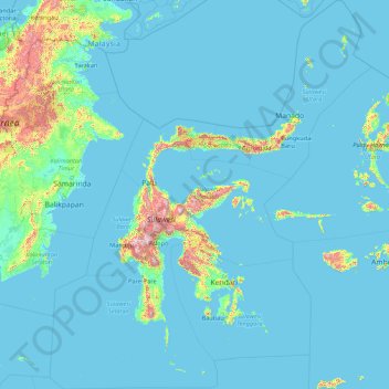
Name: Sulawesi topographic map, elevation, terrain.

Location: Sulawesi, Indonesia (-7.97221 116.34382 5.76395 127.75400)

Average elevation: 98 m

Minimum elevation: -2 m

Maximum elevation: 2,968 m

Other topographic maps

Click on a map to view its topography, its elevation and its terrain.

Aluelim

Indonesia > Aceh > Lhokseumawe

Average elevation: 20 m

Bahodopi

Indonesia > Central Sulawesi > Morowali

Average elevation: 4 m

Seradang

Indonesia > South Kalimantan > Tabalong

Average elevation: 45 m

Ambulu

Indonesia > West Java > Cirebon

Average elevation: 1 m

Pantai Ayah

Indonesia > Central Java > Kebumen > Ayah

Average elevation: 67 m

Terboyo Wetan

Indonesia > Central Java > Semarang

Average elevation: 4 m

Sipatana

Indonesia > Gorontalo > Gorontalo Utara

Average elevation: 51 m

Pasirjambu

Indonesia > Kabupaten Bandung

Average elevation: 1,141 m

Gunung Lasem

Indonesia > Central Java > Rembang

Average elevation: 510 m

Dayak Pitap

Indonesia > South Kalimantan > Balangan

Average elevation: 172 m

Mount Bromo

Indonesia

Average elevation: 2,239 m

Biak Kota

Indonesia > Papua > Biak Numfor

Average elevation: 21 m

Bongkang

Indonesia > South Kalimantan > Tabalong

Average elevation: 39 m

Dukuhturi

Indonesia > Central Java > Brebes

Average elevation: 215 m

Bulu Taba

Indonesia > Central Sulawesi

Average elevation: 1,367 m

Sumberwaras

Indonesia > Kabupaten Malang > Bulupitu

Average elevation: 357 m

Senggi

Indonesia > Papua > Keerom

Average elevation: 259 m

Upt Arso Vi / Yamua

Indonesia > Papua > Keerom

Average elevation: 45 m

Pantok

Indonesia > West Kalimantan > Sekadau

Average elevation: 115 m

Duren

Indonesia > East Java > Lumajang

Average elevation: 229 m

Uluwatu

Indonesia > Bali > Badung

Average elevation: 31 m

Sidemen

Indonesia > Bali > Karangasem

Average elevation: 409 m

Amed

Indonesia > Bali > Karangasem

Average elevation: 75 m

Baloi

Indonesia > Riau Islands > Batam

Average elevation: 24 m

Bumijawa

Indonesia > Central Java > Tegal

Average elevation: 971 m

Mandin

Indonesia > South Kalimantan > Kotabaru

Average elevation: 28 m

Buntu Sinaji

Indonesia > South Sulawesi

Average elevation: 2,130 m

Mount Sindoro

Indonesia > Central Java > Wonosobo

Average elevation: 2,572 m

Bahenap

Indonesia > West Kalimantan > Kapuas Hulu

Average elevation: 223 m

Bukit Telaga

Indonesia > West Kalimantan > Kapuas Hulu

Average elevation: 51 m

Bukit Besai

Indonesia > West Kalimantan > Kapuas Hulu

Average elevation: 482 m

Salakaria

Indonesia > West Java > Ciamis

Average elevation: 193 m

Padang Tinggi

Indonesia > Bengkulu > Kaur

Average elevation: 34 m

Monas Park

Indonesia > Central Jakarta

Average elevation: 8 m

Kijang Island

Indonesia > Riau > Reteh

Average elevation: 4 m

Bandung

Indonesia > West Java

Bandung (Sundanese: ᮘᮔ᮪ᮓᮥᮀ, romanized: Bandung, Sundanese pronunciation: [ˈbandʊŋ]; /ˈbɑːndʊŋ/) is the capital city of the Indonesian province of West Java. It has a population of 2,452,943 within its city limits according to the official estimates as at mid 2021, making it the fourth most…

Average elevation: 893 m

Rinjani

Indonesia > West Nusa Tenggara

In September 1995 an aviation report was issued concerning an unconfirmed ash cloud from Rinjani. A NOTAM about volcanic activity from Rinjani was issued by the Bali Flight Information Region on the morning of 12 September. An ash cloud was reportedly drifting to the south west with the cloud top around 4 km…

Average elevation: 3,071 m

Jatiarjo

Indonesia > East Java > Pasuruan

Average elevation: 725 m

Batee

Indonesia > Aceh > Pidie

Average elevation: 13 m

Sukalaksana

Indonesia > West Java > West Bandung > Lembang

Average elevation: 1,288 m

Bongsari

Indonesia > Central Java > Semarang

Average elevation: 26 m

Songgokerto

Indonesia > Batu

Average elevation: 1,029 m

Tlekung

Indonesia > East Java > Batu

Average elevation: 968 m

Pangea

Indonesia > Gorontalo > Gorontalo

Average elevation: 52 m

Jailolo

Indonesia > North Maluku > Halmahera Barat

Average elevation: 449 m

Ungaran

Indonesia > Central Java > Kabupaten Semarang

Ungaran (Dutch: Oengaran) is a town and adjacent areas in Central Java Province of Indonesia. The town serves as the administrative centre of the Semarang Regency in that province. Ungaran is located at -7° 8' 17", 110° 24' 18" at an elevation of 319 metres. It encompasses two districts (kecamatan) within…

Average elevation: 399 m

Balepunduk

Indonesia > Bali > Karangasem > Tegallinggah

Average elevation: 181 m

Gayamprit

Indonesia > Central Java > Klaten

Average elevation: 170 m

Asei Kecil

Indonesia > Papua > Jayapura

Average elevation: 140 m

Gandasari

Indonesia > West Java

Average elevation: 23 m

Kebun Bunga

Indonesia > South Sumatra > Palembang

Average elevation: 11 m

Cikole

Indonesia > West Java > Kabupaten Bandung

Average elevation: 1,722 m

Dusun 1

Indonesia > Central Sulawesi > Desa Jono Oge

Average elevation: 76 m

Tumiyang

Indonesia > Central Java > Banyumas

Average elevation: 324 m

Argomulyo

Indonesia > Central Java > Salatiga

Average elevation: 675 m

Banjarsari

Indonesia > Kabupaten Bandung

Average elevation: 1,520 m

Temas

Indonesia > East Java > Batu

Average elevation: 855 m

Gudangkahuripan

Indonesia > West Java > West Bandung

Average elevation: 1,121 m

Limboto

Indonesia > Gorontalo > Gorontalo

Average elevation: 32 m

Cihideung

Indonesia > West Java > West Bandung

Average elevation: 1,259 m

Kebun Raya ITERA

Indonesia > Lampung > Lampung Selatan > Way Huwi

Average elevation: 102 m

Wahoo Waterworld

Indonesia > West Bandung > Jayamekar

Average elevation: 680 m

Go! Wet Waterpark

Indonesia > West Java > Bekasi

Average elevation: 30 m

Puncak Jaya

Indonesia > Central Papua > Mimika

Puncak Jaya (Indonesian: [ˈpuntʃak ˈdʒaja]; literally "Glorious Peak", Amungme: Nemangkawi Ninggok) or Carstensz Pyramid (/ˈkɑːrstəns/, Indonesian: Piramida Carstensz, Dutch: Carstenszpiramide) on the island of New Guinea, with an elevation of 4,884 m (16,024 ft), is the highest mountain peak of an…

Average elevation: 4,271 m

Buntu Tambolang

Indonesia > South Sulawesi

Average elevation: 1,354 m

Bokor

Indonesia > Riau > Kepulauan Meranti

Average elevation: 3 m

Semar

Indonesia > Central Java > Tlogowungu

Average elevation: 296 m

Aeknabara

Indonesia > North Sumatra > Mandailing Natal

Average elevation: 422 m

Situ Cibeureum

Indonesia > West Java > Rawa Banteng

Average elevation: 31 m

Sumillan

Indonesia > South Sulawesi > Enrekang

Average elevation: 955 m

Pekkabata

Indonesia > South Sulawesi > Pinrang

Average elevation: 9 m

Sidokumpul

Indonesia > East Java > Sidoarjo > Sidoarjo

Average elevation: 4 m

Jemah

Indonesia > West Java > Sumedang

Average elevation: 279 m

Oro-oro Ombo

Indonesia > Batu

Average elevation: 952 m

Pagerwangi

Indonesia > West Java > West Bandung

Average elevation: 1,173 m

Gunung Perigi

Indonesia > West Nusa Tenggara

Average elevation: 1,336 m

Puncak Jaya

Indonesia > Central Papua > Mimika

Puncak Jaya (Indonesian: [ˈpuntʃak ˈdʒaja]; literally "Victorious Peak", Amungme: Nemangkawi Ninggok) or Carstensz Pyramid (/ˈkɑːrstəns/, Indonesian: Piramida Carstensz, Dutch: Carstenszpiramide) on the island of New Guinea, with an elevation of 4,884 m (16,024 ft), is the highest mountain peak of an…

Average elevation: 4,271 m