
Río Gualas topographic map
Interactive map
Click on the map to display elevation.
About this map
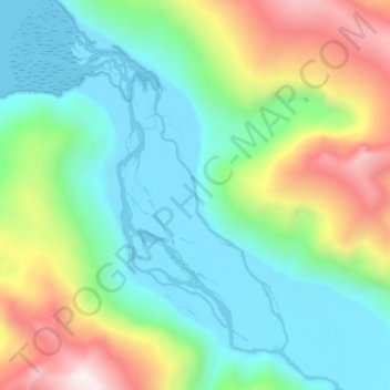
Name: Río Gualas topographic map, elevation, terrain.
Location: Río Gualas, Provincia de Aysén, Aysén Region, Chile (-46.53363 -73.74345 -46.47937 -73.67697)
Average elevation: 421 m
Minimum elevation: -2 m
Maximum elevation: 1,400 m
Other topographic maps
Click on a map to view its topography, its elevation and its terrain.
Villa Cerro Castillo
Chile > Aysén Region > Provincia de General Carrera > Río Ibáñez
Villa Cerro Castillo, Río Ibáñez, Provincia de General Carrera, Aysén Region, Chile
Average elevation: 379 m
Isla Smith
Chile > Aysén Region > Provincia de Aysén > Aysén
Isla Smith, Aysén, Provincia de Aysén, Aysén Region, Chile
Average elevation: 3 m
Villa O'Higgins
Chile > Aysén Region > Provincia de Capitán Prat > O’Higgins > Villa O'Higgins
Villa O'Higgins, O’Higgins, Provincia de Capitán Prat, Aysén Region, 6110000, Chile
Average elevation: 402 m
Cochrane
Chile > Aysén Region > Provincia de Capitán Prat > Cochrane > Cochrane
Cochrane, Provincia de Capitán Prat, Aysén Region, 3030000, Chile
Average elevation: 350 m
Puerto Aysén
Chile > Aysén Region > Provincia de Aysén > Puerto Aysén
Puerto Aysén, Aysén, Provincia de Aysén, Aysén Region, 441, Chile
Average elevation: 524 m
Chile Chico
Chile > Aysén Region > Provincia de General Carrera > Chile Chico
Chile Chico, Provincia de General Carrera, Aysén Region, 6050000, Chile
Average elevation: 911 m
Puyuhuapi
Chile > Aysén Region > Cisnes > Puyuhuapi
Puyuhuapi, Cisnes, Provincia de Aysén, Aysén Region, Chile
Average elevation: 229 m
Coyhaique
Chile > Aysén Region > Provincia de Coyhaique > Coyhaique
Coyhaique, Provincia de Coyhaique, Aysén Region, Chile
Average elevation: 870 m
Río Ibáñez
Chile > Aysén Region > Río Ibáñez
Río Ibáñez, Provincia de General Carrera, Aysén Region, Chile
Average elevation: 314 m
O’Higgins
Chile > Aysén Region > O’Higgins
O’Higgins, Provincia de Capitán Prat, Aysén Region, 6110000, Chile
Average elevation: 922 m