
Flechtingen topographic map
Interactive map
Click on the map to display elevation.
About this map
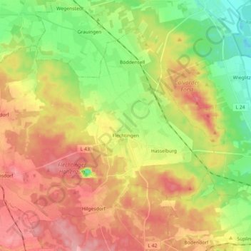
Name: Flechtingen topographic map, elevation, terrain.
Location: Flechtingen, Börde, Saksen-Anhalt, Duitsland (52.29421 11.12397 52.37855 11.30242)
Average elevation: 105 m
Minimum elevation: 49 m
Maximum elevation: 162 m
Other topographic maps
Click on a map to view its topography, its elevation and its terrain.
Dorst
Duitsland > Saksen-Anhalt > Börde > Calvörde
Dorst, Calvörde, Flechtingen, Börde, Saksen-Anhalt, Duitsland
Average elevation: 65 m
Oschersleben
Duitsland > Saksen-Anhalt > Börde
Oschersleben, Börde, Saksen-Anhalt, 39387, Duitsland
Average elevation: 112 m
Beendorf
Duitsland > Saksen-Anhalt > Börde
Beendorf, Flechtingen, Börde, Saksen-Anhalt, Duitsland
Average elevation: 134 m