
Beendorf topographic map
Interactive map
Click on the map to display elevation.
About this map
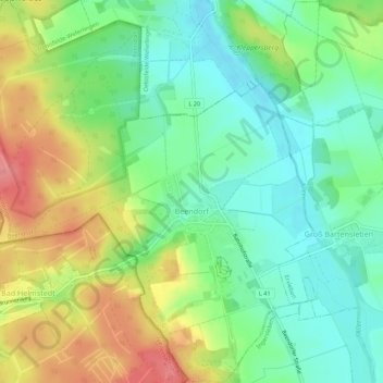
Name: Beendorf topographic map, elevation, terrain.
Location: Beendorf, Flechtingen, Börde, Saksen-Anhalt, Duitsland (52.22826 11.05222 52.26194 11.10461)
Average elevation: 134 m
Minimum elevation: 100 m
Maximum elevation: 186 m
Other topographic maps
Click on a map to view its topography, its elevation and its terrain.
Flechtingen
Duitsland > Saksen-Anhalt > Börde
Flechtingen, Börde, Saksen-Anhalt, Duitsland
Average elevation: 105 m
Dorst
Duitsland > Saksen-Anhalt > Börde > Calvörde
Dorst, Calvörde, Flechtingen, Börde, Saksen-Anhalt, Duitsland
Average elevation: 65 m
Oschersleben
Duitsland > Saksen-Anhalt > Börde
Oschersleben, Börde, Saksen-Anhalt, 39387, Duitsland
Average elevation: 112 m