
Austin topographic map
Interactive map
Click on the map to display elevation.
About this map
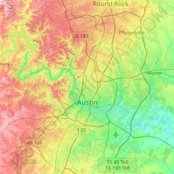
Name: Austin topographic map, elevation, terrain.
Location: Austin, Travis, Texas, Vereinigte Staaten von Amerika (30.09851 -97.93677 30.51663 -97.56053)
Average elevation: 216 m
Minimum elevation: 113 m
Maximum elevation: 386 m
1835 wurde die Stadt unter dem Namen Waterloo [ˈwɔːtəɹˌluː] gegründet, 1838 jedoch zu Ehren von Stephen F. Austin, dem Gründer der damals unabhängigen Republik Texas, umbenannt. Seit 1839 ist Austin Hauptstadt von Texas. Von 1882 bis 1888 wurde das Texas State Capitol erbaut und galt seinerzeit als siebtgrößtes Gebäude der Welt. Es ist sechs Meter höher als das Kapitol in Washington, D.C.
Other topographic maps
Click on a map to view its topography, its elevation and its terrain.
Teck
Vereinigte Staaten von Amerika > Texas > Travis
Teck, Travis, Texas, 78734, Vereinigte Staaten von Amerika
Average elevation: 230 m