
Oberägeri topographic map
Interactive map
Click on the map to display elevation.
About this map
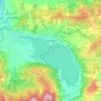
Name: Oberägeri topographic map, elevation, terrain.
Location: Oberägeri, Zug, 6315, Schweiz (47.09200 8.59451 47.16348 8.70116)
Average elevation: 912 m
Minimum elevation: 635 m
Maximum elevation: 1,446 m
Oberägeri, historisches Luftbild von 1923, aufgenommen aus 500 Metern Höhe von Walter Mittelholzer
Other topographic maps
Click on a map to view its topography, its elevation and its terrain.
Wildspitz
Schweiz > Zug > Unterägeri
Wildspitz, Unterägeri, Zug, 6314, Schweiz
Average elevation: 1,266 m