
Lone Pine topographic map
Interactive map
Click on the map to display elevation.
About this map
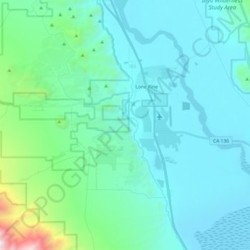
Name: Lone Pine topographic map, elevation, terrain.
Average elevation: 1,298 m
Minimum elevation: 1,084 m
Maximum elevation: 2,953 m
Lone Pine ist ein census-designated place im Inyo County des Bundesstaats Kalifornien. Das U.S. Census Bureau hat bei der Volkszählung 2020 eine Einwohnerzahl von 2.014 ermittelt. Er liegt im Owens Valley auf einer Höhe von 1136 m unter der Ostflanke der Sierra Nevada am Fuße des 4418 m hohen Mount Whitney, dem höchsten Berg der USA außerhalb Alaskas.
Other topographic maps
Click on a map to view its topography, its elevation and its terrain.
Badwater Basin
Vereinigte Staaten von Amerika > Kalifornien > Inyo County
Badwater Basin, Inyo County, Kalifornien, Vereinigte Staaten von Amerika
Average elevation: 152 m
Bishop
Vereinigte Staaten von Amerika > Kalifornien > Inyo County
Bishop, Inyo County, Kalifornien, Vereinigte Staaten von Amerika
Average elevation: 1,265 m