
Bad Driburg topographic map
Interactive map
Click on the map to display elevation.
About this map
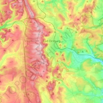
Name: Bad Driburg topographic map, elevation, terrain.
Location: Bad Driburg, Kreis Höxter, Noordrijn-Westfalen, 33014, Duitsland (51.64383 8.96421 51.79731 9.11737)
Average elevation: 282 m
Minimum elevation: 140 m
Maximum elevation: 437 m
Bad Driburg ligt in zeer heuvelachtig en soms steil hellend terrein tegen de oostflank van het Eggegebergte aan. De hoogteverschillen in de gemeente zijn soms boven de 200 meter. Deze ligging maakt dat door stijgingsregens en meer dan elders voorkomende mist in het najaar en de winter het klimaat vochtiger en koeler is dan in de directe omgeving.
Other topographic maps
Click on a map to view its topography, its elevation and its terrain.
Höxter
Duitsland > Noordrijn-Westfalen > Kreis Höxter
Höxter, Kreis Höxter, Noordrijn-Westfalen, 37671, Duitsland
Average elevation: 228 m
Warburg
Duitsland > Noordrijn-Westfalen > Kreis Höxter > Warburg
Warburg, Kreis Höxter, Noordrijn-Westfalen, 34414, Duitsland
Average elevation: 248 m
Brakel
Duitsland > Noordrijn-Westfalen > Kreis Höxter
Brakel, Kreis Höxter, Noordrijn-Westfalen, 33034, Duitsland
Average elevation: 232 m