
Höxter topographic map
Interactive map
Click on the map to display elevation.
About this map
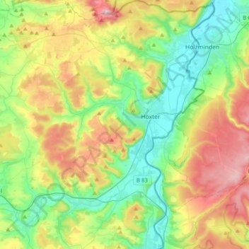
Name: Höxter topographic map, elevation, terrain.
Location: Höxter, Kreis Höxter, Noordrijn-Westfalen, 37671, Duitsland (51.67189 9.24909 51.86488 9.46174)
Average elevation: 228 m
Minimum elevation: 81 m
Maximum elevation: 495 m
Hoogte boven zeeniveau: 285 meter.
Other topographic maps
Click on a map to view its topography, its elevation and its terrain.
Bad Driburg
Duitsland > Noordrijn-Westfalen > Kreis Höxter
Bad Driburg, Kreis Höxter, Noordrijn-Westfalen, 33014, Duitsland
Average elevation: 282 m
Warburg
Duitsland > Noordrijn-Westfalen > Kreis Höxter > Warburg
Warburg, Kreis Höxter, Noordrijn-Westfalen, 34414, Duitsland
Average elevation: 248 m
Brakel
Duitsland > Noordrijn-Westfalen > Kreis Höxter
Brakel, Kreis Höxter, Noordrijn-Westfalen, 33034, Duitsland
Average elevation: 232 m