
Tuti topographic map
Click on the map to display elevation.
About this map
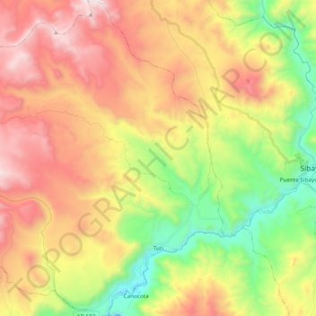
Name: Tuti topographic map, elevation, terrain.
Location: Tuti, Caylloma, Arequipa, Perú (-15.57271 -71.68114 -15.38908 -71.50993)
Average elevation: 4,404 m
Minimum elevation: 3,682 m
Maximum elevation: 5,203 m
Other topographic maps
Click on a map to view its topography, its elevation and its terrain.
Solimana
El Solimana es un volcán del Perú ubicado en la cordillera Occidental de los Andes. Es clasificado como estratovolcán y con sus 6.093 m de altitud, es una de las principales elevaciones del departamento de Arequipa. Presenta tres cumbres, que se encuentran siempre cubiertas por la nieve. Este volcán…
Average elevation: 5,567 m
Laguna de Salinas
Perú > Arequipa > San Juan de Tarucani
La Laguna de Salinas es un salar de aguas someras, que se localiza al sur del Perú, en el departamento de Arequipa, dentro de los límites de la Reserva nacional de Salinas y Aguada Blanca. Se encuentra en una depresión que forma la parte final de una cuenca endorreica, posee como máximo una extensión…
Average elevation: 4,364 m
Ampato
El Ampato (del aimara jamp'atu, 'sapo') es un volcán inactivo localizado en la Cordillera de Ampato al sur del Perú, en el distrito de Lluta. Tiene una altitud de 6.290 m s. n. m. Cerca de la cumbre de este nevado fue descubierto un cadáver congelado en septiembre de 1995 por el arqueólogo de montaña…
Average elevation: 5,784 m
El Pedregal
El Pedregal es una localidad peruana, capital del distrito de Majes, ubicado en la provincia de Caylloma, en el departamento de Arequipa. Se encuentra a una altitud de 1410 m s. n. m. Tenía una población de 2573 hab. en 1993.
Average elevation: 1,388 m
Mirador Cruz del Condor
Perú > Arequipa > Cabanaconde > Cabanaconde > San Miguel
Average elevation: 3,553 m
Valle del Colca
Perú > Arequipa > Choco > Soro
El Altiplano en el Colca está representado por una extensa meseta que se desarrolla a altitudes entre 4000 y 4500 m s. n. m.. Ésta es una superficie casi llana o suavemente ondulada, sobre la cual destacan cerros y volcanes que sobrepasan los 5000 m s. n. m.. Es en estas superficies donde sobresalen volcanes…
Average elevation: 3,169 m
Pampa de los Camarones
Perú > Arequipa > Sachaca > Guillermo Torreblanca > Pampa de los Camarones
Average elevation: 2,297 m
Ciudad Satélite
Perú > Arequipa > José Luis Bustamante y Rivero > Ciudad Satélite
Average elevation: 2,373 m
Manantial de Chancharay
Perú > Arequipa > Aplao > Hacienda La Cabecera > Yupanqui
Average elevation: 732 m