
Thank you for supporting this site ❤️
Make a donation
Make a donation
Rhaunen topographic map
Click on the map to display elevation.
Thank you for supporting this site ❤️
Make a donation
Make a donation
About this map
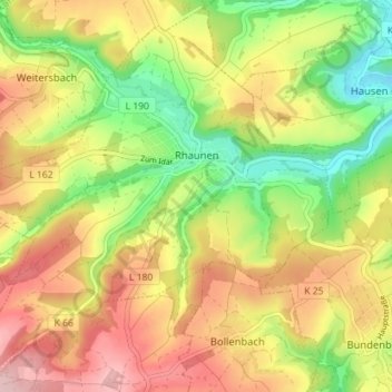
Name: Rhaunen topographic map, elevation, terrain.
Average elevation: 393 m
Minimum elevation: 296 m
Maximum elevation: 490 m
Thank you for supporting this site ❤️
Make a donation
Make a donation
Other topographic maps
Click on a map to view its topography, its elevation and its terrain.
Hallenbad Idar-Oberstein
Germany > Rhineland-Palatinate > Landkreis Birkenfeld > Idar-Oberstein
Average elevation: 343 m