
Villianur Taluk topographic map
Interactive map
Click on the map to display elevation.
About this map
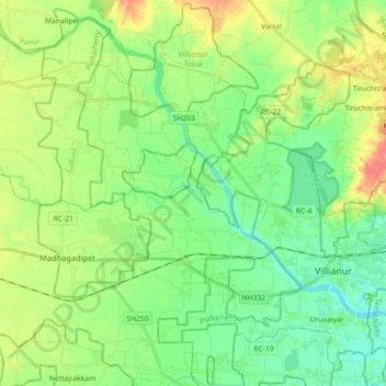
Name: Villianur Taluk topographic map, elevation, terrain.
Location: Villianur Taluk, Puducherry district, Puducherry, India (11.86209 79.61685 12.03481 79.79580)
Average elevation: 21 m
Minimum elevation: 1 m
Maximum elevation: 57 m
Other topographic maps
Click on a map to view its topography, its elevation and its terrain.
Puducherry
India > Puducherry > Puducherry Taluk
The topography of Pondicherry is the same as that of coastal Tamil Nadu. Pondicherry's average elevation is at sea level and includes a number of sea inlets, referred to locally as "backwaters". Pondicherry experiences extreme coastal erosion as a result of a breakwater constructed in 1989, just to the south…
Average elevation: 10 m
Yanam
India > Puducherry > Yanam Taluk
In December 1753, a Paravana of Salabat Jang conceded to Bussy the Northern Circars. Salabat Jang was indebted to the French East India Company for his elevation to the throne, which had been confirmed by the Mughal emperor. The agreement made between the French and Salabat Jang in Aurangabad bears the…
Average elevation: 5 m