
Zetel topographic map
Interactive map
Click on the map to display elevation.
About this map
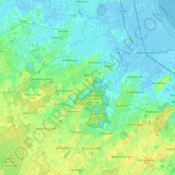
Name: Zetel topographic map, elevation, terrain.
Location: Zetel, Landkreis Friesland, Niedersachsen, 26340, Deutschland (53.33597 7.85856 53.47588 8.07222)
Average elevation: 7 m
Minimum elevation: -4 m
Maximum elevation: 19 m
Other topographic maps
Click on a map to view its topography, its elevation and its terrain.
Bockhorn
Deutschland > Niedersachsen > Landkreis Friesland
Bockhorn, Landkreis Friesland, Niedersachsen, 26345, Deutschland
Average elevation: 7 m
Varel
Deutschland > Niedersachsen > Landkreis Friesland > Varel > Varel
Varel, Landkreis Friesland, Niedersachsen, 26316, Deutschland
Average elevation: 3 m