
Bockhorn topographic map
Interactive map
Click on the map to display elevation.
About this map
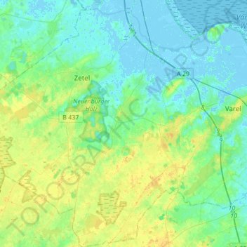
Name: Bockhorn topographic map, elevation, terrain.
Location: Bockhorn, Landkreis Friesland, Niedersachsen, 26345, Deutschland (53.30456 7.92952 53.46681 8.09962)
Average elevation: 7 m
Minimum elevation: -4 m
Maximum elevation: 20 m
Das große Oldtimer- und Teilemarkt in Bockhorn findet jährlich rund um Pfingsten (Juni) statt, Höhepunkt der Oldtimermesse ist die Friesland-Rallye mit Oldtimern und Youngtimern. Jeweils am zweiten Septemberwochenende findet mit dem Bockhorner Markt die Hauptattraktion des Jahres statt.
Other topographic maps
Click on a map to view its topography, its elevation and its terrain.
Varel
Deutschland > Niedersachsen > Landkreis Friesland > Varel > Varel
Varel, Landkreis Friesland, Niedersachsen, 26316, Deutschland
Average elevation: 3 m
Zetel
Deutschland > Niedersachsen > Landkreis Friesland
Zetel, Landkreis Friesland, Niedersachsen, 26340, Deutschland
Average elevation: 7 m