
Chengannur topographic map
Interactive map
Click on the map to display elevation.
About this map
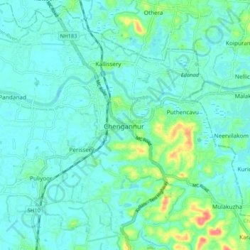
Name: Chengannur topographic map, elevation, terrain.
Location: Chengannur, Alappuzha, Kerala, 689122, India (9.27786 76.57390 9.35786 76.65390)
Average elevation: 13 m
Minimum elevation: 0 m
Maximum elevation: 68 m
Other topographic maps
Click on a map to view its topography, its elevation and its terrain.
Kodukulanji
India > Kerala > Chengannur > Kodukulanji
Kodukulanji, Chengannur, Alappuzha, Kerala, 689508, India
Average elevation: 18 m