
Make a donation
Ta'izz Governorate topographic map
Click on the map to display elevation.
Make a donation
Ta'izz Governorate
For such a small area, Taiz Governorate has an extraordinarily diverse geography. The western half of the governorate is part of the Tihamah coastal plain and has an exceedingly hot, humid and arid climate. The eastern half, however, is very mountainous, with the major peak being 3,070-metre-high Jabal Sabir, near Taiz city. These mountains trap the moisture created by an upper-level wind reversal between April and October, so that in the eastern half of the governorate annual rainfall increases from 200 millimetres (8 inches) in the foothills to probably more than 1,000 millimetres (40 inches) near Jebel Saber. Temperatures in the highlands remain high during the daytime, but at the highest elevations they can fall dramatically to -5 °C (23 °F) overnight.
Make a donation
About this map
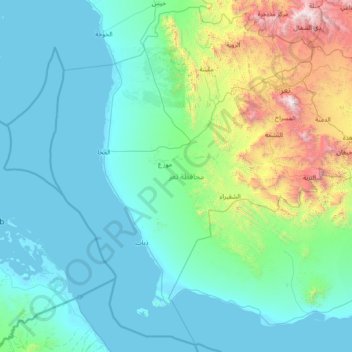
Name: Ta'izz Governorate topographic map, elevation, terrain.
Location: Ta'izz Governorate, Yemen (12.51659 43.02101 13.91466 44.51612)
Average elevation: 395 m
Minimum elevation: -2 m
Maximum elevation: 2,952 m
Make a donation
Other topographic maps
Click on a map to view its topography, its elevation and its terrain.
Make a donation
Make a donation
Make a donation
Hodeidah
Yemen > Al Hudaydah Governorate
Mountain Highlands: Notable mountains include Jabal Ras and Jabal Bura, both reaching elevations of 2,000 to 2,400 meters above sea level.
Average elevation: 16 m
Make a donation
Sana'a
At an elevation of 2,300 metres (7,500 ft), Sanaa is one of the highest capital cities in the world and is next to the Sarawat Mountains of Jabal An-Nabi Shu'ayb and Jabal Tiyal, considered to be the highest mountains in the Arabian Peninsula and one of the highest in the region. Sanaa has a population of…
Average elevation: 2,443 m
Make a donation
Make a donation