
Make a donation
Grosseto topographic map
Click on the map to display elevation.
Make a donation
Grosseto
The Province of Grosseto completely occupies the southern end of Tuscany, and with a territorial area of 4,504 square kilometres (1,739 sq mi), it is the most extensive in the region and one of the least dense in population in Italy. The province is bordered to the northwest by the Province of Livorno, to the north by the Province of Pisa, to the northeast by the Province of Siena, and to the southeast by the Province of Viterbo in Lazio. To the south is the Tyrrhenian Sea, which includes the southern islands of the Tuscan archipelago, including Isola del Giglio and the smaller Giannutri islands and Formiche di Grosseto and Formica di Burano. The Arcipelago Toscano National Park spans both the provinces of Grosseto and Livorno, and includes the seven main islands of the Tuscan Archipelago: Elba, Isola del Giglio, Capraia, Montecristo, Pianosa, Giannutri, Gorgona, and some of the minor islands and rock outcrops. The highest point in the park is Mount Capanne, at 1,019 metres (3,343 ft) in elevation, on the island of Elba.
Make a donation
About this map
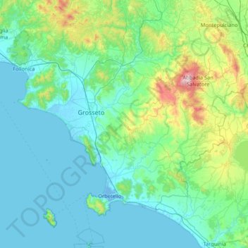
Name: Grosseto topographic map, elevation, terrain.
Location: Grosseto, Tuscany, Italy (42.23762 10.70627 43.18914 11.82016)
Average elevation: 197 m
Minimum elevation: -5 m
Maximum elevation: 1,677 m
Make a donation
Other topographic maps
Click on a map to view its topography, its elevation and its terrain.
Make a donation
Make a donation