
Prince George's County topographic map
Interactive map
Click on the map to display elevation.
About this map
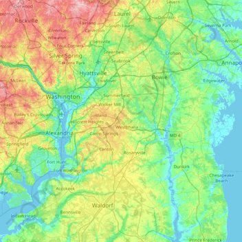
Name: Prince George's County topographic map, elevation, terrain.
Location: Prince George's County, Maryland, United States (38.53548 -77.08300 39.13190 -76.66929)
Average elevation: 45 m
Minimum elevation: -5 m
Maximum elevation: 173 m
Prince George's County lies in the Atlantic coastal plain, and its landscape is characterized by gently rolling hills and valleys. Along its western border with Montgomery County, Adelphi, Calverton and West Laurel rise into the piedmont, exceeding 300 feet (91 m) in elevation.
Other topographic maps
Click on a map to view its topography, its elevation and its terrain.
Temple Hills
United States > Maryland > Prince George's County
Temple Hills, Prince George's County, Maryland, 20748, United States
Average elevation: 66 m
Fort Meade
United States > Maryland > Anne Arundel County
Fort Meade, Anne Arundel County, Maryland, 20755, United States
Average elevation: 54 m
Baldwin
United States > Maryland > Baltimore County
Baldwin, Baltimore County, Maryland, 21082, United States
Average elevation: 130 m
Parkland Terrace
United States > Maryland > Prince George's County > Suitland
Parkland Terrace, Suitland, Prince George's County, Maryland, 20233, United States
Average elevation: 79 m
Washington County
Washington County, Maryland, United States
Average elevation: 195 m
Rolling Hills
United States > Maryland > Charles County
Rolling Hills, Charles County, Maryland, 20611, United States
Average elevation: 44 m
Middle East
United States > Maryland > Baltimore
Middle East, Baltimore, Maryland, United States
Average elevation: 29 m
Chesapeake Forest
United States > Maryland > Wicomico County > Gum Swamp
Chesapeake Forest, Gum Swamp, Wicomico County, Maryland, United States
Average elevation: 3 m
Annapolis
United States > Maryland > Annapolis
Annapolis, Anne Arundel County, Maryland, United States
Average elevation: 8 m
Bethesda
United States > Maryland > Montgomery County > Bethesda
Bethesda, Montgomery County, Maryland, United States
Average elevation: 81 m
Garrett Park
United States > Maryland > Montgomery County > Garrett Park
Garrett Park, Montgomery County, Maryland, 20896, United States
Average elevation: 90 m
Parkside
United States > Maryland > Montgomery County > Parkside
Parkside, Montgomery County, Maryland, 20852-3385, United States
Average elevation: 93 m
Rock Hall
United States > Maryland > Frederick County > Point of Rocks > Rock Hall
Rock Hall, Point of Rocks, Frederick County, Maryland, 21777, United States
Average elevation: 93 m
Rogers Heights
United States > Maryland > Prince George's County > East Riverdale
Rogers Heights, East Riverdale, Prince George's County, Maryland, 20710, United States
Average elevation: 29 m