Geolocate

Washington County topographic map

Interactive map

Click on the map to display elevation.

About this map

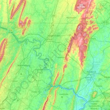
Name: Washington County topographic map, elevation, terrain.

Location: Washington County, Maryland, United States (39.31829 -78.36331 39.72258 -77.46887)

Average elevation: 195 m

Minimum elevation: 60 m

Maximum elevation: 647 m

Other topographic maps

Click on a map to view its topography, its elevation and its terrain.

Temple Hills

United States > Maryland > Prince George's County

Temple Hills, Prince George's County, Maryland, 20748, United States

Average elevation: 66 m

Fort Meade

United States > Maryland > Anne Arundel County

Fort Meade, Anne Arundel County, Maryland, 20755, United States

Average elevation: 54 m

Baldwin

United States > Maryland > Baltimore County

Baldwin, Baltimore County, Maryland, 21082, United States

Average elevation: 130 m

Parkland Terrace

United States > Maryland > Prince George's County > Suitland

Parkland Terrace, Suitland, Prince George's County, Maryland, 20233, United States

Average elevation: 79 m

Rolling Hills

United States > Maryland > Charles County

Rolling Hills, Charles County, Maryland, 20611, United States

Average elevation: 44 m

Middle East

United States > Maryland > Baltimore

Middle East, Baltimore, Maryland, United States

Average elevation: 29 m

Chesapeake Forest

United States > Maryland > Wicomico County > Gum Swamp

Chesapeake Forest, Gum Swamp, Wicomico County, Maryland, United States

Average elevation: 3 m

Annapolis

United States > Maryland > Annapolis

Annapolis, Anne Arundel County, Maryland, United States

Average elevation: 8 m

Bethesda

United States > Maryland > Montgomery County > Bethesda

Bethesda, Montgomery County, Maryland, United States

Average elevation: 81 m

Garrett Park

United States > Maryland > Montgomery County > Garrett Park

Garrett Park, Montgomery County, Maryland, 20896, United States

Average elevation: 90 m

Parkside

United States > Maryland > Montgomery County > Parkside

Parkside, Montgomery County, Maryland, 20852-3385, United States

Average elevation: 93 m

Rock Hall

United States > Maryland > Frederick County > Point of Rocks > Rock Hall

Rock Hall, Point of Rocks, Frederick County, Maryland, 21777, United States

Average elevation: 93 m

Rogers Heights

United States > Maryland > Prince George's County > East Riverdale

Rogers Heights, East Riverdale, Prince George's County, Maryland, 20710, United States

Average elevation: 29 m

Prince George's County

United States > Maryland

Prince George's County, Maryland, United States

Average elevation: 45 m