
Community of Madrid topographic map
Interactive map
Click on the map to display elevation.
About this map
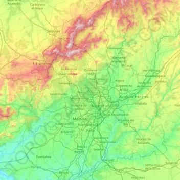
Name: Community of Madrid topographic map, elevation, terrain.
Location: Community of Madrid, Spain (39.88458 -4.57901 41.16574 -3.05299)
Average elevation: 852 m
Minimum elevation: 385 m
Maximum elevation: 2,404 m
The mountain amphibians living at a high altitude include the fire salamander, the marbled newt, the alpine newt, the iberian frog, the European tree frog or the common midwife toad. At a middle elevation in the mountain reaches close to water streams there are species such as the Bosca's newt, the southern marbled newt, the mediterranean tree frog or the iberian midwife toad. The common parsley frog and the Alytes obstetricans pertinax dwell in the limestone lowlands near the Tagus in the south-east of the region. Among the all-around amphibians adaptable to different heights stand out the natterjack toad, the common toad and the iberian green frog. Other species with a wide distribution range (although in this case restricted by altitude) are the gallipato, the iberian spadefoot toad, the iberian painted frog, and the Spanish painted frog.
Other topographic maps
Click on a map to view its topography, its elevation and its terrain.
Madrid
Spain > Community of Madrid > Área metropolitana de Madrid y Corredor del Henares
Madrid, Área metropolitana de Madrid y Corredor del Henares, Community of Madrid, Spain
Average elevation: 671 m
Montecillo
Spain > Community of Madrid > Villaconejos
Montecillo, Villaconejos, Community of Madrid, 28360, Spain
Average elevation: 677 m
Madrid
Spain > Community of Madrid > Área metropolitana de Madrid y Corredor del Henares > Madrid
Madrid, Área metropolitana de Madrid y Corredor del Henares, Community of Madrid, 28080, Spain
Average elevation: 650 m
Alcalá de Henares
Spain > Community of Madrid > Alcalá de Henares
Alcalá de Henares, Área metropolitana de Madrid y Corredor del Henares, Community of Madrid, Spain
Average elevation: 642 m
San Lorenzo de El Escorial
Spain > Community of Madrid > San Lorenzo de El Escorial
San Lorenzo de El Escorial, Cuenca del Guadarrama, Community of Madrid, 28200, Spain
Average elevation: 1,179 m
Casco Histórico de Vallecas
Spain > Community of Madrid > Madrid
Casco Histórico de Vallecas, Villa de Vallecas, Madrid, Área metropolitana de Madrid y Corredor del Henares, Community of Madrid, 28001, Spain
Average elevation: 604 m
Leganés
Spain > Community of Madrid > Leganés
Leganés, Área metropolitana de Madrid y Corredor del Henares, Community of Madrid, Spain
Average elevation: 656 m
El Atazar
Spain > Community of Madrid > El Atazar
El Atazar, Sierra Norte, Community of Madrid, Spain
Average elevation: 1,010 m
Iberian Peninsula
Spain > Community of Madrid > Aldea del Fresno
Iberian Peninsula, Carretera de acceso a Calalberche, Calalberche, Serantes, Aldea del Fresno, Sierra Oeste, Toledo, Community of Madrid, Spain
Average elevation: 351 m
Manzanares
Manzanares, Área metropolitana de Madrid y Corredor del Henares, Community of Madrid, 28410, Spain
Average elevation: 765 m
Goya
Spain > Community of Madrid > Madrid
Goya, Salamanca, Madrid, Área metropolitana de Madrid y Corredor del Henares, Community of Madrid, 28001, Spain
Average elevation: 676 m