
Thank you for supporting this site ❤️
Make a donation
Make a donation
Anelghowat topographic map
Click on the map to display elevation.
Thank you for supporting this site ❤️
Make a donation
Make a donation
About this map
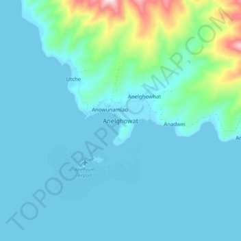
Name: Anelghowat topographic map, elevation, terrain.
Location: Anelghowat, Tafea, Vanuatu (-20.27545 169.74296 -20.19545 169.82296)
Average elevation: 72 m
Minimum elevation: -1 m
Maximum elevation: 571 m
Thank you for supporting this site ❤️
Make a donation
Make a donation
Other topographic maps
Click on a map to view its topography, its elevation and its terrain.