Geolocate

Wrexham topographic map

Click on the map to display elevation.

About this map

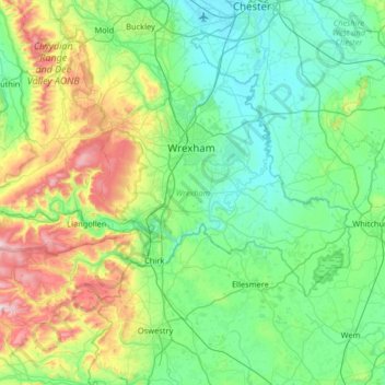
Name: Wrexham topographic map, elevation, terrain.

Location: Wrexham, Wales, United Kingdom (52.86659 -3.37552 53.13431 -2.72413)

Average elevation: 150 m

Minimum elevation: 3 m

Maximum elevation: 649 m

Other topographic maps

Click on a map to view its topography, its elevation and its terrain.

Newport

United Kingdom > Wales > Newport

Average elevation: 89 m

Wrexham

United Kingdom > Wales > Wrexham

Average elevation: 139 m

Cardiff

United Kingdom > Wales > Cardiff

Average elevation: 55 m

Hay on Wye

United Kingdom > Wales > Powys

Average elevation: 199 m

Rhyl

United Kingdom > Wales > Denbighshire

Average elevation: 5 m

Brecon

United Kingdom > Wales > Powys

Average elevation: 216 m

Llandarcy

United Kingdom > Wales > Neath Port Talbot

Average elevation: 29 m

Ruthin

United Kingdom > Wales > Denbighshire

The Myddleton Arms is also known as the Seven Eyes. It is said to have been built in the 14th century. The Dutch style design, long, steeped roof is attributed to Sir Richard Clough, an Elizabethan merchant. It has four tiers of dormer windows, each at a different elevation, known locally as the seven eyes of…

Average elevation: 162 m

Denbigh

United Kingdom > Wales > Denbighshire

Average elevation: 102 m

Glasbury

United Kingdom > Wales > Powys

Average elevation: 125 m

Bullwell Bay

United Kingdom > Wales

Average elevation: 14 m

Beaufort

United Kingdom > Wales > Blaenau Gwent

Average elevation: 384 m

Tremadog Bay

United Kingdom > Wales

Average elevation: 0 m

Swansea

United Kingdom > Wales > Swansea

Much of Swansea is hilly with the main area of upland being located in the council ward of Mawr. Areas up to 185 metres (607 ft) in elevation range across the central section: Kilvey Hill, Townhill and Llwynmawr separate the centre of Swansea from its northern suburbs. Cefn Bryn, a ridge of high land, is the…

Average elevation: 73 m

Abergavenny

United Kingdom > Wales > Monmouthshire

Average elevation: 187 m

Pontypridd

United Kingdom > Wales > Pontypridd

Average elevation: 184 m

Monmouth

United Kingdom > Wales > Monmouthshire

Average elevation: 101 m

Carmarthen

United Kingdom > Wales > Carmarthenshire

Average elevation: 74 m

Cwmbrân

United Kingdom > Wales > Torfaen

Average elevation: 138 m

Brymbo

United Kingdom > Wales > Wrexham

While there was mining of coal in the area on a small scale, the late eighteenth century saw an expansion in activity, particularly after the industrialist John "Iron-Mad" Wilkinson purchased Brymbo Hall and began developing its estate, mining coal and ironstone and building an ironworks which was later to…

Average elevation: 195 m

Snowdon

United Kingdom > Wales > Gwynedd

Snowdon (/ˈsnoʊdən/) or Yr Wyddfa (pronounced [ər ˈʊɨ̞̯ðva] (listen)), is the highest mountain in Wales, at an elevation of 1,085 metres (3,560 ft) above sea level, and the highest point in the British Isles outside the Scottish Highlands. It is located in Snowdonia National Park (Parc Cenedlaethol…

Average elevation: 692 m

Rhossili

United Kingdom > Wales > Swansea

Average elevation: 41 m

Dylife

United Kingdom > Wales > Powys

Average elevation: 396 m

Tonypandy

United Kingdom > Wales > Rhondda Cynon Taf

Average elevation: 285 m

Shirenewton

United Kingdom > Wales > Monmouthshire

Average elevation: 108 m

Aberystwyth

United Kingdom > Wales > Ceredigion

Aberystwyth experiences an oceanic climate (Köppen climate classification Cfb) similar to almost all of the United Kingdom. This is particularly pronounced due to its west coast location facing the Irish Sea. Air undergoes little land moderation and so temperatures closely reflect the sea temperature when…

Average elevation: 39 m

Prestatyn

United Kingdom > Wales > Denbighshire

Average elevation: 48 m

Llanelli

United Kingdom > Wales > Carmarthenshire

Average elevation: 41 m

Cambrian Mountains

United Kingdom > Wales > Powys

Average elevation: 319 m

Dolfor

United Kingdom > Wales > Powys

Average elevation: 330 m

Hill Mountain

United Kingdom > Wales > Pembrokeshire > Llangwm

Average elevation: 52 m

Llanidloes

United Kingdom > Wales > Powys

Average elevation: 267 m

Heneglwys

United Kingdom > Wales > Isle of Anglesey > Bodffordd

Average elevation: 58 m

Graigwen

United Kingdom > Wales > Rhondda Cynon Taf > Pontypridd

Average elevation: 159 m

Three Crosses

United Kingdom > Wales > Swansea

Average elevation: 82 m

Nantmor

United Kingdom > Wales > Gwynedd

Average elevation: 150 m

Tan-y-groes

United Kingdom > Wales > Ceredigion

Average elevation: 143 m

Foel Penolau

United Kingdom > Wales

Average elevation: 423 m

Ysgafell Wen

United Kingdom > Wales

Average elevation: 517 m

Moel Yr Hydd

United Kingdom > Wales

Average elevation: 429 m

Taff

United Kingdom > Wales

Average elevation: 270 m

Harlech

United Kingdom > Wales > Gwynedd

Average elevation: 68 m

Fron Goch

United Kingdom > Wales

Average elevation: 196 m

Yr Eifl

United Kingdom > Wales

Average elevation: 257 m

Mynydd Carningli

United Kingdom > Wales

Average elevation: 213 m

Dudwell Mountain

United Kingdom > Wales

Average elevation: 118 m

Penhros Coppice

United Kingdom > Wales

Average elevation: 107 m

Cefn Coch

United Kingdom > Wales

Average elevation: 328 m

Cefn Coch

United Kingdom > Wales

Average elevation: 458 m

Gwynedd

United Kingdom > Wales

Average elevation: 332 m

Powys

United Kingdom > Wales

Average elevation: 285 m

Isle of Anglesey

United Kingdom > Wales

Average elevation: 65 m

Aberedw

United Kingdom > Wales > Powys

Average elevation: 256 m

Clocaenog

United Kingdom > Wales > Denbighshire

Average elevation: 259 m

Cwm-Cou

United Kingdom > Wales > Ceredigion

Average elevation: 90 m

Llanfechain

United Kingdom > Wales > Powys

Average elevation: 146 m

Caehopkin

United Kingdom > Wales > Powys

Average elevation: 235 m

Cynwyl Elfed

United Kingdom > Wales > Carmarthenshire

Average elevation: 150 m

Meinciau

United Kingdom > Wales > Carmarthenshire

Average elevation: 125 m

Pontyclun

United Kingdom > Wales > Rhondda Cynon Taf

Average elevation: 72 m

Llandrillo

United Kingdom > Wales > Denbighshire

Average elevation: 272 m

Bryneglwys

United Kingdom > Wales > Denbighshire

Average elevation: 319 m

St Asaph

United Kingdom > Wales > Denbighshire

Average elevation: 125 m

Sodom

United Kingdom > Wales > Denbighshire > St Asaph

Average elevation: 129 m

Pennard

United Kingdom > Wales > Swansea

Average elevation: 47 m

Foel Eglwyseg

United Kingdom > Wales > Denbighshire

Average elevation: 302 m

Velindre

United Kingdom > Wales > Carmarthenshire > Drefach

Average elevation: 114 m

Rhyd-y-sarn

United Kingdom > Wales > Gwynedd > Llan Ffestiniog

Average elevation: 167 m

Cefn Coch

United Kingdom > Wales > Powys

Average elevation: 255 m

Sennybridge

United Kingdom > Wales > Powys

Average elevation: 261 m

Rhoshirwaun

United Kingdom > Wales > Gwynedd

Average elevation: 77 m

Coed Maes-gwyn

United Kingdom > Wales > Gwynedd > Llanuwchllyn

Average elevation: 224 m

Trefnant

United Kingdom > Wales > Denbighshire

Average elevation: 59 m

Glyder Fawr

United Kingdom > Wales > Gwynedd

Average elevation: 671 m

Llyn y Fan Fach

United Kingdom > Wales > Carmarthenshire

Llyn y Fan Fach (Welsh meaning "little lake of the peak") is a lake of approximately 10 hectares (25 acres) on the northern margin of the Black Mountain in Carmarthenshire, South Wales and lying within the Brecon Beacons National Park. The lake lies at an altitude of approximately 1,660 feet (510 m),…

Average elevation: 549 m

Y Bontuchel

United Kingdom > Wales > Denbighshire

Average elevation: 202 m

Rhyd-y-fro

United Kingdom > Wales > Neath Port Talbot

Average elevation: 184 m

Pontyates

United Kingdom > Wales > Carmarthenshire

Average elevation: 82 m

Cynwyd

United Kingdom > Wales > Denbighshire

Average elevation: 246 m

Rhuallt

United Kingdom > Wales > Denbighshire

Average elevation: 134 m

Llanynys

United Kingdom > Wales > Denbighshire

Average elevation: 56 m

Cwmystwyth

United Kingdom > Wales > Ceredigion > Pontarfynach

Average elevation: 372 m

Lightwood Green

United Kingdom > Wales > Wrexham

Average elevation: 62 m

Forden

United Kingdom > Wales > Powys

Average elevation: 103 m

Cefn

United Kingdom > Wales > Powys

Average elevation: 139 m

Pant-yr-hwddwch

United Kingdom > Wales > Pembrokeshire

Average elevation: 186 m

Llechwedd

United Kingdom > Wales > Conwy

Average elevation: 366 m

Llanwrtyd Wells

United Kingdom > Wales > Powys

Average elevation: 296 m

Crossgates

United Kingdom > Wales > Powys

Average elevation: 225 m

St Harmon

United Kingdom > Wales > Powys

Average elevation: 334 m