Geolocate

Mynydd Carningli topographic map

Click on the map to display elevation.

About this map

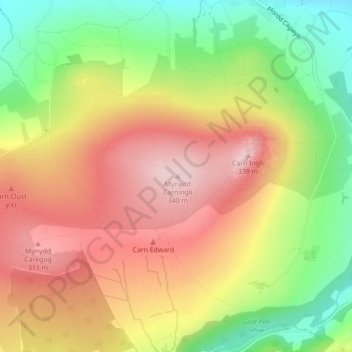
Name: Mynydd Carningli topographic map, elevation, terrain.

Location: Mynydd Carningli, Pembrokeshire, Wales, SA42 0QT, United Kingdom (51.99792 -4.83294 51.99802 -4.83284)

Average elevation: 213 m

Minimum elevation: 73 m

Maximum elevation: 337 m

Other topographic maps

Click on a map to view its topography, its elevation and its terrain.

North Wales

United Kingdom > Wales

Average elevation: 125 m

South Wales

United Kingdom > Wales

Average elevation: 163 m

Powys

United Kingdom > Wales

Average elevation: 216 m

Neath Port Talbot

United Kingdom > Wales

Average elevation: 188 m

Newport

United Kingdom > Wales

Average elevation: 58 m

Barry

United Kingdom > Wales > Vale of Glamorgan

Average elevation: 29 m

Pembrokeshire

United Kingdom > Wales

There is little evidence of Roman occupation in what is now Pembrokeshire. Ptolemy's Geography, written c. 150, mentioned some coastal places, two of which have been identified as the River Teifi and what is now St Davids Head, but most Roman writers did not mention the area; there may have been a Roman…

Average elevation: 43 m

Isle of Anglesey

United Kingdom > Wales

Average elevation: 49 m

Gwynedd

United Kingdom > Wales

Average elevation: 199 m

Bullwell Bay

United Kingdom > Wales

Average elevation: 14 m

Wrexham

United Kingdom > Wales

Average elevation: 150 m

Bridgend County Borough

United Kingdom > Wales

Average elevation: 160 m

Conwy

United Kingdom > Wales

Average elevation: 254 m

Carmarthenshire

United Kingdom > Wales

Average elevation: 142 m

Rhondda Cynon Taf

United Kingdom > Wales

Average elevation: 251 m

Ceredigion

United Kingdom > Wales

Average elevation: 213 m

Denbighshire

United Kingdom > Wales

Average elevation: 213 m

Flintshire

United Kingdom > Wales

Average elevation: 104 m

Torfaen

United Kingdom > Wales

Exterior A large iron framed market hall with two full elevations and three secondary entrances through other street frontages, eg. Jubilee Building, Crane Street. Built of grey narrow coursed rock faced pennant limestone with some larger stones, and with yellow Ebbw Vale brick dressings and a Welsh slate…

Average elevation: 206 m

Blaenau Gwent

United Kingdom > Wales

Average elevation: 358 m

Monmouthshire

United Kingdom > Wales

Average elevation: 136 m

Eryri National Park

United Kingdom > Wales > Gwynedd

Average elevation: 217 m

Vale of Glamorgan

United Kingdom > Wales

Average elevation: 56 m

Brecon Beacons National Park

United Kingdom > Wales > Powys

Brecon Beacons National Park, officially named Bannau Brycheiniog National Park (Welsh pronunciation), is a national park in Wales. It is named after the Brecon Beacons (Welsh: Bannau Brycheiniog), the mountain range at its centre. The national park includes the highest mountain in South Wales, Pen y Fan,…

Average elevation: 270 m

Anglesey

United Kingdom > Wales > Isle of Anglesey

Average elevation: 43 m

River Dee

United Kingdom > Wales

Average elevation: 157 m

Taff

United Kingdom > Wales

Average elevation: 270 m

Llanedi

United Kingdom > Wales > Carmarthenshire > Llanedi

Average elevation: 104 m

Llanelly

United Kingdom > Wales

Average elevation: 306 m

Ystradgynlais

United Kingdom > Wales

Average elevation: 285 m

The Vale of Grwyney

United Kingdom > Wales

Average elevation: 329 m

Ammanford

United Kingdom > Wales

Average elevation: 55 m

Llandinam

United Kingdom > Wales

Average elevation: 297 m

Penhros Coppice

United Kingdom > Wales

Average elevation: 107 m

Maenclochog

United Kingdom > Wales

Average elevation: 182 m

Penrice

United Kingdom > Wales

Average elevation: 55 m

Merthyr Tydfil County Borough

United Kingdom > Wales

Merthyr Tydfil Golf Club is situated on the southeastern slopes of Cefn Cil Sanws, a rough gritstone and limestone hill in the north-west of the County Borough. It is one of the highest golf courses in Britain. Morlais Castle Golf Club is situated adjacent to the ruins of Morlais Castle on Morlais Hill,…

Average elevation: 328 m

Swansea

United Kingdom > Wales

Average elevation: 76 m

Presteigne

United Kingdom > Wales > Powys > Norton

Average elevation: 259 m

Roath

United Kingdom > Wales > Cardiff > Cardiff

Average elevation: 20 m

Clawddnewydd

United Kingdom > Wales > Denbighshire

Average elevation: 246 m

Coed Maes-gwyn

United Kingdom > Wales > Gwynedd > Llanuwchllyn

Average elevation: 224 m

Llyn y Fan Fach

United Kingdom > Wales > Carmarthenshire

Llyn y Fan Fach (Welsh meaning "little lake of the peak") is a lake of approximately 10 hectares (25 acres) on the northern margin of the Black Mountain in Carmarthenshire, South Wales and lying within the Brecon Beacons National Park. The lake lies at an altitude of approximately 1,660 feet (510 m),…

Average elevation: 549 m

St. Julians

United Kingdom > Wales > Newport

Average elevation: 23 m

Neath

United Kingdom > Wales > Neath Port Talbot

Average elevation: 71 m

Pontardawe

United Kingdom > Wales > Neath Port Talbot

Average elevation: 180 m

Betws Gwerfil Goch

United Kingdom > Wales > Denbighshire

Average elevation: 297 m

Pembroke Dock

United Kingdom > Wales > Pembrokeshire

Average elevation: 19 m

Blorenge

United Kingdom > Wales > Monmouthshire > Govilon

Average elevation: 394 m

Ponthir

United Kingdom > Wales > Torfaen

Average elevation: 48 m

Morriston

United Kingdom > Wales > Swansea > Swansea

Average elevation: 66 m

Brecon Beacons

United Kingdom > Wales > Powys > Libanus

Average elevation: 436 m

River Teifi

United Kingdom > Wales > Carmarthenshire

Average elevation: 155 m

River Vyrnwy

United Kingdom > Wales > Powys

Average elevation: 206 m

River Monnow

United Kingdom > Wales > Monmouthshire

Average elevation: 172 m

River Conwy

United Kingdom > Wales > Conwy > Pentrefelin

Average elevation: 38 m

River Clwyd

United Kingdom > Wales > Denbighshire

Average elevation: 214 m

Llyn Cowlyd

United Kingdom > Wales > Conwy

Average elevation: 481 m

Llyn Eigiau

United Kingdom > Wales > Conwy > Caerhun

Average elevation: 491 m

Llyn Padarn

United Kingdom > Wales > Gwynedd > Llanberis

Average elevation: 186 m

Llyn Gwynant

United Kingdom > Wales > Gwynedd > Beddgelert > Nantgwynant

Average elevation: 246 m

Llyn Cwellyn

United Kingdom > Wales > Gwynedd > Betws Garmon

Average elevation: 263 m

Llyn y Fan Fawr

United Kingdom > Wales > Powys > Llywel

Average elevation: 610 m

Swansea Bay

United Kingdom > Wales > Swansea > Mumbles

Average elevation: 25 m

Skomer

United Kingdom > Wales > Pembrokeshire

Average elevation: 14 m

Skokholm

United Kingdom > Wales > Pembrokeshire

Average elevation: 3 m

Ramsey Island

United Kingdom > Wales > Pembrokeshire > St Davids

Average elevation: 14 m

Caldey Island

United Kingdom > Wales > Pembrokeshire

Caldey Island is about 1.5 miles (2.4 km) long and 1 mile (1.6 km) in width at its widest. It has an area of 538 acres (2.18 km2) and its highest elevation is 197 feet (60 m). The island lies in Carmarthen Bay on the northern side of the Bristol Channel in the county of Pembrokeshire, a little over 2.5 miles…

Average elevation: 5 m

Flat Holm

United Kingdom > Wales > Cardiff

Average elevation: 0 m

Hirnant

United Kingdom > Wales > Gwynedd > Llangywer

Average elevation: 382 m

Penarth

United Kingdom > Wales > Vale of Glamorgan

Average elevation: 17 m

Banwy

United Kingdom > Wales > Powys

Average elevation: 333 m

Tremorfa

United Kingdom > Wales > Cardiff > Cardiff

Average elevation: 8 m

VC48 Merionethshire

United Kingdom > Wales > Gwynedd

Average elevation: 237 m

Black Mountain

United Kingdom > Wales > Powys > Pen y Cae

Average elevation: 312 m

Clynnog

United Kingdom > Wales > Gwynedd

Average elevation: 96 m

Llyn Ogwen

United Kingdom > Wales > Gwynedd

Average elevation: 487 m

Bryn Iwan

United Kingdom > Wales > Carmarthenshire

Average elevation: 252 m

Whitland

United Kingdom > Wales > Carmarthenshire

Average elevation: 52 m

Llanegryn

United Kingdom > Wales > Gwynedd

Average elevation: 116 m

River Towy

United Kingdom > Wales > Carmarthenshire

Average elevation: 215 m

Llanfairfechan

United Kingdom > Wales > Conwy

Average elevation: 186 m

Dyffryn Ardudwy

United Kingdom > Wales > Gwynedd

Average elevation: 152 m

Llyn Cau

United Kingdom > Wales > Gwynedd

Average elevation: 555 m