
Thank you for supporting this site ❤️
Make a donation
Make a donation
Kuttippuram topographic map
Click on the map to display elevation.
Thank you for supporting this site ❤️
Make a donation
Make a donation
About this map
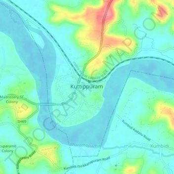
Name: Kuttippuram topographic map, elevation, terrain.
Location: Kuttippuram, Tirur, Malappuram District, Kerala, 679571, India (10.80457 75.99307 10.88457 76.07307)
Average elevation: 26 m
Minimum elevation: -6 m
Maximum elevation: 112 m
Thank you for supporting this site ❤️
Make a donation
Make a donation
Other topographic maps
Click on a map to view its topography, its elevation and its terrain.