
Thank you for supporting this site ❤️
Make a donation
Make a donation
Union Bay Natural Area topographic map
Click on the map to display elevation.
Thank you for supporting this site ❤️
Make a donation
Make a donation
About this map
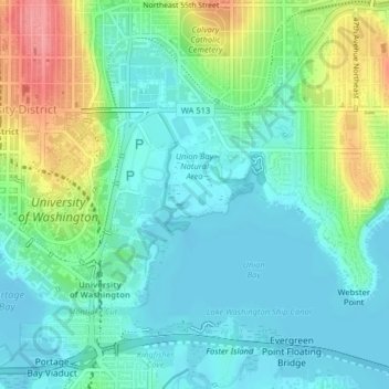
Name: Union Bay Natural Area topographic map, elevation, terrain.
Average elevation: 24 m
Minimum elevation: -2 m
Maximum elevation: 84 m
Thank you for supporting this site ❤️
Make a donation
Make a donation
Other topographic maps
Click on a map to view its topography, its elevation and its terrain.
Thank you for supporting this site ❤️
Make a donation
Make a donation
Donnie Chin International Children’s Park
United States > Washington > King County > Seattle
Average elevation: 43 m