
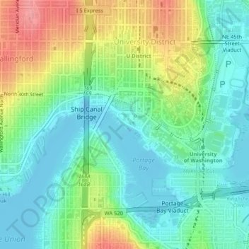
Fritz Hedges Waterway Park topographic map
Interactive map
Click on the map to display elevation.
About this map
Name: Fritz Hedges Waterway Park topographic map, elevation, terrain.
Average elevation: 32 m
Minimum elevation: -16 m
Maximum elevation: 96 m
Other topographic maps
Click on a map to view its topography, its elevation and its terrain.
Kerry Park
United States > Washington > King County > Seattle
Kerry Park, 211, Queen Anne, Seattle, King County, Washington, 98119, United States
Average elevation: 52 m
Peace Park
United States > Washington > King County > Seattle
Peace Park, West Campus, University District, Seattle, King County, Washington, United States
Average elevation: 39 m
Madison Park
United States > Washington > King County > Seattle
Madison Park, Seattle, King County, Washington, 98112, United States, Washington Park Arboretum
Average elevation: 40 m
Discovery Park
United States > Washington > King County > Seattle
Discovery Park, Magnolia, Seattle, King County, Washington, 98199, United States
Average elevation: 28 m
Green Lake
United States > Washington > King County > Seattle
Green Lake, Seattle, King County, Washington, 98103, United States
Average elevation: 75 m
Union Bay Natural Area
United States > Washington > King County > Seattle
Union Bay Natural Area, Canal Road Northeast, East Campus, University District, Seattle, King County, Washington, 98105, United States
Average elevation: 24 m
Ravenna Park
United States > Washington > King County > Seattle
Ravenna Park, University District, Seattle, King County, Washington, 98105, United States
Average elevation: 63 m
The Big Tree
United States > Washington > King County > Seattle
The Big Tree, 3400, East Harrison Street, Denny-Blaine, Harrison/Denny–Blaine, Seattle, King County, Washington, 98112, United States
Average elevation: 43 m
Othello Park
United States > Washington > King County > Seattle
Othello Park, Dunlap, Seattle, King County, Washington, 98118, United States
Average elevation: 39 m
Donnie Chin International Children’s Park
United States > Washington > King County > Seattle
Donnie Chin International Children’s Park, Little Saigon, International District/Chinatown, Seattle, King County, Washington, United States
Average elevation: 43 m