
Make a donation
Manado topographic map
Click on the map to display elevation.
Make a donation
About this map
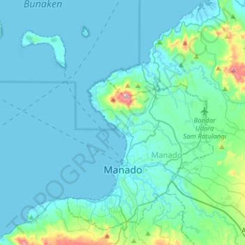
Name: Manado topographic map, elevation, terrain.
Location: Manado, North Sulawesi, Sulawesi, Indonesia (1.42802 124.68155 1.64919 124.93412)
Average elevation: 62 m
Minimum elevation: 0 m
Maximum elevation: 617 m
Make a donation
Other topographic maps
Click on a map to view its topography, its elevation and its terrain.
Ruang
Indonesia > North Sulawesi > Kepulauan Siau Tagulandang Biaro > Pumpente
Ruang is the southernmost stratovolcano in the Sangihe Islands arc, North Sulawesi, Indonesia. It comprises an island 4 by 5 kilometres (2.5 mi × 3.1 mi) wide. The summit contains a partial lava dome and reaches some 725 metres (2,379 ft) in altitude. From its summit, Klabat's peak in the south, that of Siau…
Average elevation: 274 m
Make a donation
Sawang Bendar
Indonesia > North Sulawesi > Kepulauan Sangihe > Kelurahan Sawang Bendar
Average elevation: 86 m