
Thank you for supporting this site ❤️
Make a donation
Make a donation
Sarhad-e Broghil topographic map
Click on the map to display elevation.
Thank you for supporting this site ❤️
Make a donation
Make a donation
About this map
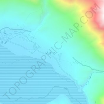
Name: Sarhad-e Broghil topographic map, elevation, terrain.
Average elevation: 3,444 m
Minimum elevation: 3,249 m
Maximum elevation: 4,535 m
Thank you for supporting this site ❤️
Make a donation
Make a donation
Other topographic maps
Click on a map to view its topography, its elevation and its terrain.
Thank you for supporting this site ❤️
Make a donation
Make a donation
Thank you for supporting this site ❤️
Make a donation
Make a donation
Thank you for supporting this site ❤️
Make a donation
Make a donation
Thank you for supporting this site ❤️
Make a donation
Make a donation
Shuhada
Afghanistan > Badakhshan Province
Shuhada is a mountainous district situated in the southern part of the Hindu Kush range. The region is characterized by high-altitude valleys, narrow river gorges, and scattered agricultural plains. The climate is continental, with cold winters and temperate summers. The district is largely rural and isolated,…
Average elevation: 3,276 m
Thank you for supporting this site ❤️
Make a donation
Make a donation