
Make a donation
Shuhada topographic map
Click on the map to display elevation.
Make a donation
Shuhada
Shuhada is a mountainous district situated in the southern part of the Hindu Kush range. The region is characterized by high-altitude valleys, narrow river gorges, and scattered agricultural plains. The climate is continental, with cold winters and temperate summers. The district is largely rural and isolated, which contributes to its preservation of traditional lifestyles.
Make a donation
About this map
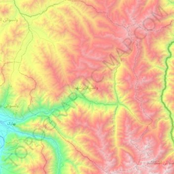
Name: Shuhada topographic map, elevation, terrain.
Location: Shuhada, Badakhshan Province, Afghanistan (36.85056 70.91689 37.34587 71.39795)
Average elevation: 3,276 m
Minimum elevation: 1,422 m
Maximum elevation: 5,319 m
Make a donation
Other topographic maps
Click on a map to view its topography, its elevation and its terrain.
Make a donation
Koran va Monjan
Afghanistan > Badakhshan Province > Kuran wa Munjan
Owing to its altitude, Kuran wa Munjan features a subarctic climate (Dsc) bordering on a tundra climate (ET) under the Köppen climate classification. It has brief, pleasant summers and very cold, snowy winters. Winters are extremely long with below-freezing months from October until May. Summers are very…
Average elevation: 3,132 m
Make a donation