
Füssen topographic map
Interactive map
Click on the map to display elevation.
About this map
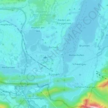
Name: Füssen topographic map, elevation, terrain.
Location: Füssen, Landkreis Ostallgäu, Beieren, 87629, Duitsland (47.55099 10.58277 47.62047 10.72727)
Average elevation: 852 m
Minimum elevation: 773 m
Maximum elevation: 1,915 m
Other topographic maps
Click on a map to view its topography, its elevation and its terrain.
Waal
Duitsland > Beieren > Landkreis Ostallgäu
Waal, Buchloe, Landkreis Ostallgäu, Beieren, 86875, Duitsland
Average elevation: 651 m
Lechbruck a.See
Duitsland > Beieren > Landkreis Ostallgäu > Lechbruck a.See
Lechbruck a.See, Landkreis Ostallgäu, Beieren, 86983, Duitsland
Average elevation: 772 m