
Thank you for supporting this site ❤️
Make a donation
Make a donation
Hohenpeißenberg topographic map
Click on the map to display elevation.
Thank you for supporting this site ❤️
Make a donation
Make a donation
Hohenpeißenberg
The climate is oceanic (Köppen: Cfb), affected by altitude and proximity to the Alps (especially in precipitation). Registering data continuously since 1781, the Hohenpeißenberg Observatory is the oldest in the world located on a mountain. The station located in the alpine foothills integrates the German Meteorological Network and served for the program Global Atmospheric Watch program (GAW).
Thank you for supporting this site ❤️
Make a donation
Make a donation
About this map
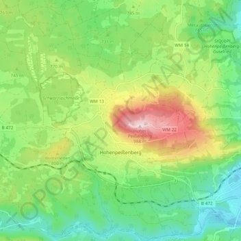
Name: Hohenpeißenberg topographic map, elevation, terrain.
Average elevation: 732 m
Minimum elevation: 592 m
Maximum elevation: 986 m
Thank you for supporting this site ❤️
Make a donation
Make a donation
Other topographic maps
Click on a map to view its topography, its elevation and its terrain.
Thank you for supporting this site ❤️
Make a donation
Make a donation
Schwabsoien
Germany > Bavaria > Landkreis Weilheim-Schongau > Schwabsoien > Schwabsoien
Average elevation: 763 m