
Xiashan District topographic map
Interactive map
Click on the map to display elevation.
About this map
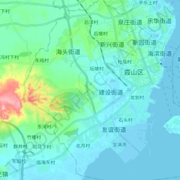
Name: Xiashan District topographic map, elevation, terrain.
Location: Xiashan District, Zhanjiang City, Guangdong, PRC (21.12049 110.31531 21.24295 110.44235)
Average elevation: 22 m
Minimum elevation: -4 m
Maximum elevation: 157 m
Other topographic maps
Click on a map to view its topography, its elevation and its terrain.
Science City
PRC > Guangdong > Guangzhou City
Science City, 联和街道, Huangpu District, Guangzhou City, Guangdong, PRC
Average elevation: 27 m
Baiyun District
PRC > Guangdong > Guangzhou City
Baiyun District, Guangzhou City, Guangdong, PRC
Average elevation: 40 m