
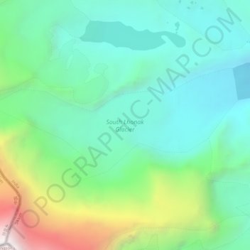
South Lhonak Glacier topographic map
Interactive map
Click on the map to display elevation.
About this map
Name: South Lhonak Glacier topographic map, elevation, terrain.
Average elevation: 5,830 m
Minimum elevation: 5,225 m
Maximum elevation: 7,457 m
Other topographic maps
Click on a map to view its topography, its elevation and its terrain.
Kangchenjunga
India > Sikkim > Chungthang
Kangchenjunga Main is the highest elevation of the Brahmaputra River basin, which forms part of the southeast Asian monsoon regime and is among the globally largest river basins. Kangchenjunga is one of six peaks above 8,000 m (26,000 ft) located in the basin of the Kosi River, which is among the largest…
Average elevation: 7,725 m
Lachung
India > Sikkim > Chungthang
Lachung is a town and hill station in northeast Sikkim, India. It is located in the North Sikkim district near the border with Tibet. Lachung is at an elevation of about 9,600 feet (2,900 m) and at the confluence of the Lachen and Lachung Rivers, both tributaries of the River Teesta. The word Lachung means…
Average elevation: 3,617 m
Lachung
India > Sikkim > Chungthang
Lachung is a town and hill station in northeast Sikkim, India. It is located in the North Sikkim district near the border with Tibet. Lachung is at an elevation of about 9,600 feet (2,900 m) and at the confluence of the lachen and Lachung Rivers, both tributaries of the River Teesta. The word Lachung means…
Average elevation: 3,617 m