
Thank you for supporting this site ❤️
Make a donation
Make a donation
Thangu Valley topographic map
Click on the map to display elevation.
Thank you for supporting this site ❤️
Make a donation
Make a donation
About this map
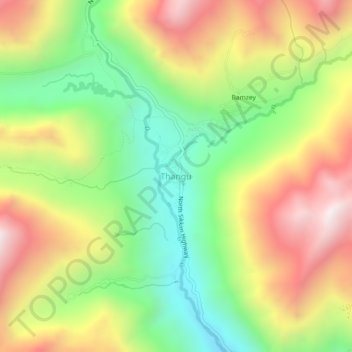
Name: Thangu Valley topographic map, elevation, terrain.
Location: Thangu Valley, Chungthang, Mangan, Sikkim, India (27.87250 88.51596 27.91250 88.55596)
Average elevation: 4,243 m
Minimum elevation: 3,733 m
Maximum elevation: 4,846 m
Thank you for supporting this site ❤️
Make a donation
Make a donation
Other topographic maps
Click on a map to view its topography, its elevation and its terrain.
Gurudongmar
India > Sikkim > Chungthang
Gurudongmar Lake is one of the highest lakes in the world and in India, at an elevation of 5,430 m (17,800 ft) according to the Government of Sikkim. It is located in the Great Himalayas in the Mangan District in Indian state of Sikkim, and considered sacred by Buddhists and Sikhs. The lake is named after…
Average elevation: 5,232 m
Thank you for supporting this site ❤️
Make a donation
Make a donation