
Dean Township topographic map
Interactive map
Click on the map to display elevation.
About this map
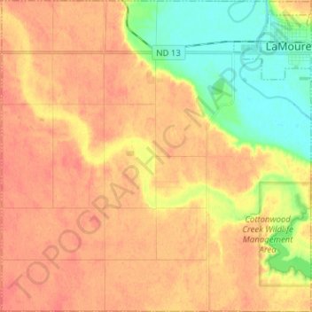
Name: Dean Township topographic map, elevation, terrain.
Location: Dean Township, LaMoure County, North Dakota, United States (46.28293 -98.41077 46.36997 -98.28539)
Average elevation: 425 m
Minimum elevation: 395 m
Maximum elevation: 442 m
Other topographic maps
Click on a map to view its topography, its elevation and its terrain.
Edgeley
United States > North Dakota > LaMoure County
Edgeley, LaMoure County, North Dakota, 58433, United States
Average elevation: 475 m