
Glasofen topographic map
Interactive map
Click on the map to display elevation.
About this map
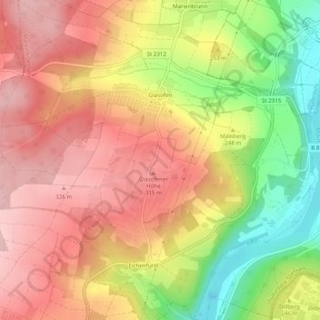
Name: Glasofen topographic map, elevation, terrain.
Average elevation: 254 m
Minimum elevation: 133 m
Maximum elevation: 336 m
Other topographic maps
Click on a map to view its topography, its elevation and its terrain.
Eichenfürst
Deutschland > Bayern > Landkreis Main-Spessart > Marktheidenfeld > Altfeld
Eichenfürst, Glasofen, Altfeld, Marktheidenfeld, Landkreis Main-Spessart, Bayern, 97828, Deutschland
Average elevation: 253 m
Marienbrunn
Deutschland > Bayern > Landkreis Main-Spessart > Marktheidenfeld
Marienbrunn, Marktheidenfeld, Landkreis Main-Spessart, Bayern, Deutschland
Average elevation: 234 m
Dillberg
Deutschland > Bayern > Landkreis Main-Spessart > Marktheidenfeld
Dillberg, Marktheidenfeld, Landkreis Main-Spessart, Bayern, 97828, Deutschland
Average elevation: 203 m
Altfeld
Deutschland > Bayern > Landkreis Main-Spessart > Marktheidenfeld
Altfeld, Marktheidenfeld, Landkreis Main-Spessart, Bayern, 97828, Deutschland
Average elevation: 271 m