
Make a donation
Dillberg topographic map
Click on the map to display elevation.
Make a donation
About this map
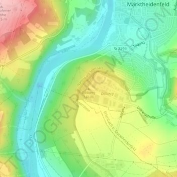
Name: Dillberg topographic map, elevation, terrain.
Average elevation: 203 m
Minimum elevation: 133 m
Maximum elevation: 314 m
Make a donation
Other topographic maps
Click on a map to view its topography, its elevation and its terrain.
97828
Deutschland > Bayern > Landkreis Main-Spessart > Marktheidenfeld > Marienbrunn
Average elevation: 270 m
Altfeld
Deutschland > Bayern > Landkreis Main-Spessart > Marktheidenfeld
Der topographisch höchste Punkt der Gemarkung Altfeld befindet sich auf 371 m ü. NHN (Lage)49.835839.52862 am Birkenschlag, der niedrigste liegt etwa 350 Meter westsüdwestlich der Mündung des Klingelsbachgrabens auf 214 m ü. NHN (Lage)49.810639.58505.
Average elevation: 274 m
Make a donation