
Thank you for supporting this site ❤️
Make a donation
Make a donation
San Marcos topographic map
Click on the map to display elevation.
Thank you for supporting this site ❤️
Make a donation
Make a donation
San Marcos
The climate varies widely within the department, due to the dramatic differences in altitude, with the north possessing a cold Guatemalan Highlands climate and the south having a temperate or hot climate, depending on the specific altitude.
Thank you for supporting this site ❤️
Make a donation
Make a donation
About this map
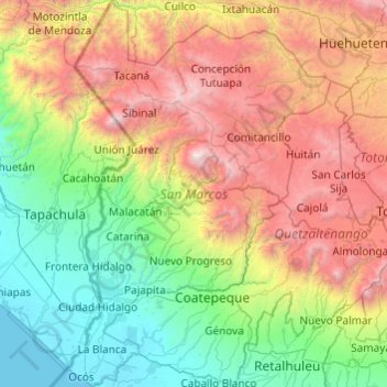
Name: San Marcos topographic map, elevation, terrain.
Location: San Marcos, Guatemala (14.48489 -92.22825 15.42140 -91.56852)
Average elevation: 1,345 m
Minimum elevation: -1 m
Maximum elevation: 4,177 m
Thank you for supporting this site ❤️
Make a donation
Make a donation
Other topographic maps
Click on a map to view its topography, its elevation and its terrain.